
Microsoft Planetary Computer Sentinel-1 RTC Imagery
Contents
Microsoft Planetary Computer Sentinel-1 RTC Imagery#
This book will demonstrate how to access radiometrically terrain corrected Sentinel-1 imagery from Microsoft Planetary Computer using stackstac. STAC stands for spatio-temporal asset catalog, it is a common framework to describe geospatial information and a way for data providers, developers and users to work and communicate efficiently. You can read more about STAC here and checkout more useful tutorials for working with STAC data.
Learning goals#
introduction to working with STAC data
using
pystacto query cloud-hosted datasets, observe metadatausing
stackstacto read cloud-hosted data as xarray objectsusing
xarrayto manipulate and organize Sentinel-1 SAR dataperforming grouping and reductions on
xarrrayobjectsvisualizing
xarrayobjects usingFacetGrid
import xarray as xr
import geopandas as gpd
import matplotlib.pyplot as plt
import numpy as np
import pandas as pd
import requests
import rich.table
import planetary_computer
from pystac_client import Client
#import cartopy
from shapely.geometry import Polygon
import rioxarray as rio
import pystac

from IPython.display import Image
We will use the pystac_client package to interact with and query the Microsoft Planetary Computer Sentinel-1 RTC dataset. In the cell below, we will create an object called catalog by calling the .open() method of the Client class. This is establishing a connection with the hosted data at the url provided. Explore the catalog object. You
STAC items#
catalog = Client.open('https://planetarycomputer.microsoft.com/api/stac/v1')
catalog
Client: microsoft-pc
| ID: microsoft-pc |
| Title: Microsoft Planetary Computer STAC API |
| Description: Searchable spatiotemporal metadata describing Earth science datasets hosted by the Microsoft Planetary Computer |
| type: Catalog |
| conformsTo: ['http://www.opengis.net/spec/ogcapi-features-1/1.0/conf/core', 'http://www.opengis.net/spec/ogcapi-features-1/1.0/conf/geojson', 'http://www.opengis.net/spec/ogcapi-features-1/1.0/conf/oas30', 'https://api.stacspec.org/v1.0.0-rc.1/collections', 'https://api.stacspec.org/v1.0.0-rc.1/core', 'https://api.stacspec.org/v1.0.0-rc.1/item-search', 'https://api.stacspec.org/v1.0.0-rc.1/item-search#fields', 'https://api.stacspec.org/v1.0.0-rc.1/item-search#filter:basic-cql', 'https://api.stacspec.org/v1.0.0-rc.1/item-search#filter:cql-json', 'https://api.stacspec.org/v1.0.0-rc.1/item-search#filter:cql-text', 'https://api.stacspec.org/v1.0.0-rc.1/item-search#filter:filter', 'https://api.stacspec.org/v1.0.0-rc.1/item-search#filter:item-search-filter', 'https://api.stacspec.org/v1.0.0-rc.1/item-search#query', 'https://api.stacspec.org/v1.0.0-rc.1/item-search#sort', 'https://api.stacspec.org/v1.0.0-rc.1/ogcapi-features'] |
Children
Only the first child shown
CollectionClient: daymet-annual-pr
| ID: daymet-annual-pr |
| Title: Daymet Annual Puerto Rico |
| Description: Annual climate summaries derived from [Daymet](https://daymet.ornl.gov) Version 4 daily data at a 1 km x 1 km spatial resolution for five variables: minimum and maximum temperature, precipitation, vapor pressure, and snow water equivalent. Annual averages are provided for minimum and maximum temperature, vapor pressure, and snow water equivalent, and annual totals are provided for the precipitation variable. [Daymet](https://daymet.ornl.gov/) provides measurements of near-surface meteorological conditions; the main purpose is to provide data estimates where no instrumentation exists. The dataset covers the period from January 1, 1980 to the present. Each year is processed individually at the close of a calendar year. Data are in a Lambert conformal conic projection for North America and are distributed in Zarr and NetCDF formats, compliant with the [Climate and Forecast (CF) metadata conventions (version 1.6)](http://cfconventions.org/). Use the DOI at [https://doi.org/10.3334/ORNLDAAC/1852](https://doi.org/10.3334/ORNLDAAC/1852) to cite your usage of the data. This dataset provides coverage for Hawaii; North America and Puerto Rico are provided in [separate datasets](https://planetarycomputer.microsoft.com/dataset/group/daymet#annual). |
| Providers: |
| type: Collection |
| title: Daymet Annual Puerto Rico |
| assets: {'thumbnail': {'href': 'https://ai4edatasetspublicassets.blob.core.windows.net/assets/pc_thumbnails/daymet-annual-pr.png', 'type': 'image/png', 'roles': ['thumbnail'], 'title': 'Daymet annual Puerto Rico map thumbnail'}, 'zarr-abfs': {'href': 'abfs://daymet-zarr/annual/pr.zarr', 'type': 'application/vnd+zarr', 'roles': ['data', 'zarr', 'abfs'], 'title': 'Annual Puerto Rico Daymet Azure Blob File System Zarr root', 'description': 'Azure Blob File System of the annual Puerto Rico Daymet Zarr Group on Azure Blob Storage for use with adlfs.', 'xarray:open_kwargs': {'consolidated': True}, 'xarray:storage_options': {'account_name': 'daymeteuwest'}}, 'zarr-https': {'href': 'https://daymeteuwest.blob.core.windows.net/daymet-zarr/annual/pr.zarr', 'type': 'application/vnd+zarr', 'roles': ['data', 'zarr', 'https'], 'title': 'Annual Puerto Rico Daymet HTTPS Zarr root', 'description': 'HTTPS URI of the annual Puerto Rico Daymet Zarr Group on Azure Blob Storage.', 'xarray:open_kwargs': {'consolidated': True}}} |
| sci:doi: 10.3334/ORNLDAAC/1852 |
| keywords: ['Daymet', 'Puerto Rico', 'Temperature', 'Precipitation', 'Vapor Pressure', 'Climate'] |
| providers: [{'url': 'https://planetarycomputer.microsoft.com', 'name': 'Microsoft', 'roles': ['host', 'processor']}, {'url': 'https://doi.org/10.3334/ORNLDAAC/1852', 'name': 'ORNL DAAC', 'roles': ['producer']}] |
| sci:citation: Thornton, M.M., R. Shrestha, Y. Wei, P.E. Thornton, S. Kao, and B.E. Wilson. 2020. Daymet: Annual Climate Summaries on a 1-km Grid for North America, Version 4. ORNL DAAC, Oak Ridge, Tennessee, USA. https://doi.org/10.3334/ORNLDAAC/1852 |
| msft:group_id: daymet |
| cube:variables: {'vp': {'type': 'data', 'unit': 'Pa', 'attrs': {'units': 'Pa', 'long_name': 'annual average of daily average vapor pressure', 'cell_methods': 'area: mean time: mean within days time: mean over days', 'grid_mapping': 'lambert_conformal_conic'}, 'shape': [41, 231, 364], 'chunks': [1, 231, 364], 'dimensions': ['time', 'y', 'x'], 'description': 'annual average of daily average vapor pressure'}, 'lat': {'type': 'auxiliary', 'unit': 'degrees_north', 'attrs': {'units': 'degrees_north', 'long_name': 'latitude coordinate', 'standard_name': 'latitude'}, 'shape': [231, 364], 'chunks': [231, 364], 'dimensions': ['y', 'x'], 'description': 'latitude coordinate'}, 'lon': {'type': 'auxiliary', 'unit': 'degrees_east', 'attrs': {'units': 'degrees_east', 'long_name': 'longitude coordinate', 'standard_name': 'longitude'}, 'shape': [231, 364], 'chunks': [231, 364], 'dimensions': ['y', 'x'], 'description': 'longitude coordinate'}, 'swe': {'type': 'data', 'unit': 'kg/m2', 'attrs': {'units': 'kg/m2', 'long_name': 'annual average snow water equivalent', 'cell_methods': 'area: mean time: sum within days time: mean over days', 'grid_mapping': 'lambert_conformal_conic'}, 'shape': [41, 231, 364], 'chunks': [1, 231, 364], 'dimensions': ['time', 'y', 'x'], 'description': 'annual average snow water equivalent'}, 'prcp': {'type': 'data', 'unit': 'mm', 'attrs': {'units': 'mm', 'long_name': 'annual total precipitation', 'cell_methods': 'area: mean time: sum within days time: sum over days', 'grid_mapping': 'lambert_conformal_conic'}, 'shape': [41, 231, 364], 'chunks': [1, 231, 364], 'dimensions': ['time', 'y', 'x'], 'description': 'annual total precipitation'}, 'tmax': {'type': 'data', 'unit': 'degrees C', 'attrs': {'units': 'degrees C', 'long_name': 'annual average of daily maximum temperature', 'cell_methods': 'area: mean time: maximum within days time: mean over days', 'grid_mapping': 'lambert_conformal_conic'}, 'shape': [41, 231, 364], 'chunks': [1, 231, 364], 'dimensions': ['time', 'y', 'x'], 'description': 'annual average of daily maximum temperature'}, 'tmin': {'type': 'data', 'unit': 'degrees C', 'attrs': {'units': 'degrees C', 'long_name': 'annual average of daily minimum temperature', 'cell_methods': 'area: mean time: minimum within days time: mean over days', 'grid_mapping': 'lambert_conformal_conic'}, 'shape': [41, 231, 364], 'chunks': [1, 231, 364], 'dimensions': ['time', 'y', 'x'], 'description': 'annual average of daily minimum temperature'}, 'time_bnds': {'type': 'data', 'attrs': {'time': 'days since 1950-01-01 00:00:00'}, 'shape': [41, 2], 'chunks': [1, 2], 'dimensions': ['time', 'nv']}, 'lambert_conformal_conic': {'type': 'data', 'attrs': {'false_easting': 0.0, 'false_northing': 0.0, 'semi_major_axis': 6378137.0, 'grid_mapping_name': 'lambert_conformal_conic', 'standard_parallel': [25.0, 60.0], 'inverse_flattening': 298.257223563, 'latitude_of_projection_origin': 42.5, 'longitude_of_central_meridian': -100.0}, 'shape': [], 'dimensions': []}} |
| msft:container: daymet-zarr |
| cube:dimensions: {'x': {'axis': 'x', 'step': 1000.0, 'type': 'spatial', 'extent': [3445750.0, 3808750.0], 'description': 'x coordinate of projection', 'reference_system': {'name': 'undefined', 'type': 'ProjectedCRS', '$schema': 'https://proj.org/schemas/v0.4/projjson.schema.json', 'base_crs': {'name': 'undefined', 'datum': {'name': 'undefined', 'type': 'GeodeticReferenceFrame', 'ellipsoid': {'name': 'undefined', 'semi_major_axis': 6378137, 'inverse_flattening': 298.257223563}}, 'coordinate_system': {'axis': [{'name': 'Longitude', 'unit': 'degree', 'direction': 'east', 'abbreviation': 'lon'}, {'name': 'Latitude', 'unit': 'degree', 'direction': 'north', 'abbreviation': 'lat'}], 'subtype': 'ellipsoidal'}}, 'conversion': {'name': 'unknown', 'method': {'id': {'code': 9802, 'authority': 'EPSG'}, 'name': 'Lambert Conic Conformal (2SP)'}, 'parameters': [{'id': {'code': 8823, 'authority': 'EPSG'}, 'name': 'Latitude of 1st standard parallel', 'unit': 'degree', 'value': 25}, {'id': {'code': 8824, 'authority': 'EPSG'}, 'name': 'Latitude of 2nd standard parallel', 'unit': 'degree', 'value': 60}, {'id': {'code': 8821, 'authority': 'EPSG'}, 'name': 'Latitude of false origin', 'unit': 'degree', 'value': 42.5}, {'id': {'code': 8822, 'authority': 'EPSG'}, 'name': 'Longitude of false origin', 'unit': 'degree', 'value': -100}, {'id': {'code': 8826, 'authority': 'EPSG'}, 'name': 'Easting at false origin', 'unit': 'metre', 'value': 0}, {'id': {'code': 8827, 'authority': 'EPSG'}, 'name': 'Northing at false origin', 'unit': 'metre', 'value': 0}]}, 'coordinate_system': {'axis': [{'name': 'Easting', 'unit': 'metre', 'direction': 'east', 'abbreviation': 'E'}, {'name': 'Northing', 'unit': 'metre', 'direction': 'north', 'abbreviation': 'N'}], 'subtype': 'Cartesian'}}}, 'y': {'axis': 'y', 'step': -1000.0, 'type': 'spatial', 'extent': [-1995000.0, -1765000.0], 'description': 'y coordinate of projection', 'reference_system': {'name': 'undefined', 'type': 'ProjectedCRS', '$schema': 'https://proj.org/schemas/v0.4/projjson.schema.json', 'base_crs': {'name': 'undefined', 'datum': {'name': 'undefined', 'type': 'GeodeticReferenceFrame', 'ellipsoid': {'name': 'undefined', 'semi_major_axis': 6378137, 'inverse_flattening': 298.257223563}}, 'coordinate_system': {'axis': [{'name': 'Longitude', 'unit': 'degree', 'direction': 'east', 'abbreviation': 'lon'}, {'name': 'Latitude', 'unit': 'degree', 'direction': 'north', 'abbreviation': 'lat'}], 'subtype': 'ellipsoidal'}}, 'conversion': {'name': 'unknown', 'method': {'id': {'code': 9802, 'authority': 'EPSG'}, 'name': 'Lambert Conic Conformal (2SP)'}, 'parameters': [{'id': {'code': 8823, 'authority': 'EPSG'}, 'name': 'Latitude of 1st standard parallel', 'unit': 'degree', 'value': 25}, {'id': {'code': 8824, 'authority': 'EPSG'}, 'name': 'Latitude of 2nd standard parallel', 'unit': 'degree', 'value': 60}, {'id': {'code': 8821, 'authority': 'EPSG'}, 'name': 'Latitude of false origin', 'unit': 'degree', 'value': 42.5}, {'id': {'code': 8822, 'authority': 'EPSG'}, 'name': 'Longitude of false origin', 'unit': 'degree', 'value': -100}, {'id': {'code': 8826, 'authority': 'EPSG'}, 'name': 'Easting at false origin', 'unit': 'metre', 'value': 0}, {'id': {'code': 8827, 'authority': 'EPSG'}, 'name': 'Northing at false origin', 'unit': 'metre', 'value': 0}]}, 'coordinate_system': {'axis': [{'name': 'Easting', 'unit': 'metre', 'direction': 'east', 'abbreviation': 'E'}, {'name': 'Northing', 'unit': 'metre', 'direction': 'north', 'abbreviation': 'N'}], 'subtype': 'Cartesian'}}}, 'nv': {'type': 'count', 'values': [0, 1], 'description': "Size of the 'time_bnds' variable."}, 'time': {'type': 'temporal', 'extent': ['1980-07-01T12:00:00Z', '2020-07-01T12:00:00Z'], 'description': '24-hour day based on local time'}} |
| msft:group_keys: ['annual', 'puerto rico'] |
| stac_extensions: ['https://stac-extensions.github.io/scientific/v1.0.0/schema.json', 'https://stac-extensions.github.io/datacube/v2.0.0/schema.json'] |
| msft:storage_account: daymeteuwest |
| msft:short_description: Annual climate summaries on a 1-km grid for Puerto Rico |
STAC Extensions
| https://stac-extensions.github.io/scientific/v1.0.0/schema.json |
| https://stac-extensions.github.io/datacube/v2.0.0/schema.json |
Links
Link:
| Rel: items |
| Target: https://planetarycomputer.microsoft.com/api/stac/v1/collections/daymet-annual-pr/items |
| Media Type: application/geo+json |
Link:
Microsoft Planetary Computer STAC API
| Rel: root |
| Target: |
| Media Type: application/json |
Link:
EOSDIS Data Use Policy
| Rel: license |
| Target: https://science.nasa.gov/earth-science/earth-science-data/data-information-policy |
Link:
| Rel: cite-as |
| Target: https://doi.org/10.3334/ORNLDAAC/1852 |
Link:
Human readable dataset overview and reference
| Rel: describedby |
| Target: https://planetarycomputer.microsoft.com/dataset/daymet-annual-pr |
| Media Type: text/html |
Link:
| Rel: self |
| Target: https://planetarycomputer.microsoft.com/api/stac/v1/collections/daymet-annual-pr |
| Media Type: application/json |
Link:
Microsoft Planetary Computer STAC API
| Rel: parent |
| Target: |
| Media Type: application/json |
Assets
Asset: Daymet annual Puerto Rico map thumbnail
| href: https://ai4edatasetspublicassets.blob.core.windows.net/assets/pc_thumbnails/daymet-annual-pr.png |
| Title: Daymet annual Puerto Rico map thumbnail |
| Media type: image/png |
| Roles: ['thumbnail'] |
| Owner: |
Asset: Annual Puerto Rico Daymet Azure Blob File System Zarr root
| href: abfs://daymet-zarr/annual/pr.zarr |
| Title: Annual Puerto Rico Daymet Azure Blob File System Zarr root |
| Description: Azure Blob File System of the annual Puerto Rico Daymet Zarr Group on Azure Blob Storage for use with adlfs. |
| Media type: application/vnd+zarr |
| Roles: ['data', 'zarr', 'abfs'] |
| Owner: |
| xarray:open_kwargs: {'consolidated': True} |
| xarray:storage_options: {'account_name': 'daymeteuwest'} |
Asset: Annual Puerto Rico Daymet HTTPS Zarr root
| href: https://daymeteuwest.blob.core.windows.net/daymet-zarr/annual/pr.zarr |
| Title: Annual Puerto Rico Daymet HTTPS Zarr root |
| Description: HTTPS URI of the annual Puerto Rico Daymet Zarr Group on Azure Blob Storage. |
| Media type: application/vnd+zarr |
| Roles: ['data', 'zarr', 'https'] |
| Owner: |
| xarray:open_kwargs: {'consolidated': True} |
Items
Only the first item shown
Item: UKESM1-0-LL.ssp585.2100
| ID: UKESM1-0-LL.ssp585.2100 |
| Bounding Box: [-180, -90, 180, 90] |
| datetime: None |
| cmip6:year: 2100 |
| cmip6:model: UKESM1-0-LL |
| end_datetime: 2100-12-30T12:00:00Z |
| cmip6:scenario: ssp585 |
| cube:variables: {'pr': {'type': 'data', 'unit': 'kg m-2 s-1', 'attrs': {'units': 'kg m-2 s-1', 'comment': 'includes both liquid and solid phases', 'long_name': 'Precipitation', 'cell_methods': 'area: time: mean', 'cell_measures': 'area: areacella', 'original_name': 'mo: (stash: m01s05i216, lbproc: 128)', 'standard_name': 'precipitation_flux'}, 'shape': [360, 600, 1440], 'dimensions': ['time', 'lat', 'lon'], 'description': 'Precipitation'}, 'tas': {'type': 'data', 'unit': 'K', 'attrs': {'units': 'K', 'comment': 'near-surface (usually, 2 meter) air temperature; derived from downscaled tasmax & tasmin', 'long_name': 'Daily Near-Surface Air Temperature', 'cell_methods': 'area: mean time: maximum', 'cell_measures': 'area: areacella', 'original_name': 'mo: (stash: m01s03i236, lbproc: 8192)', 'standard_name': 'air_temperature'}, 'shape': [360, 600, 1440], 'dimensions': ['time', 'lat', 'lon'], 'description': 'Daily Near-Surface Air Temperature'}, 'hurs': {'type': 'data', 'unit': '%', 'attrs': {'units': '%', 'comment': 'The relative humidity with respect to liquid water for T> 0 C, and with respect to ice for T<0 C.', 'long_name': 'Near-Surface Relative Humidity', 'cell_methods': 'area: time: mean', 'cell_measures': 'area: areacella', 'original_name': 'mo: (stash: m01s03i245, lbproc: 128)', 'standard_name': 'relative_humidity'}, 'shape': [360, 600, 1440], 'dimensions': ['time', 'lat', 'lon'], 'description': 'Near-Surface Relative Humidity'}, 'huss': {'type': 'data', 'unit': '1', 'attrs': {'units': '1', 'comment': 'Near-surface (usually, 2 meter) specific humidity.', 'long_name': 'Near-Surface Specific Humidity', 'cell_methods': 'area: time: mean', 'cell_measures': 'area: areacella', 'original_name': 'mo: (stash: m01s03i237, lbproc: 128)', 'standard_name': 'specific_humidity'}, 'shape': [360, 600, 1440], 'dimensions': ['time', 'lat', 'lon'], 'description': 'Near-Surface Specific Humidity'}, 'rlds': {'type': 'data', 'unit': 'W m-2', 'attrs': {'units': 'W m-2', 'comment': "mo: For instantaneous outputs, this diagnostic represents an average over the radiation time step using the state of the atmosphere (T,q,clouds) from the first dynamics step within that interval. The time coordinate is the start of the radiation time step interval, so the value for t(N) is the average from t(N) to t(N+1)., ScenarioMIP_table_comment: The surface called 'surface' means the lower boundary of the atmosphere. 'longwave' means longwave radiation. Downwelling radiation is radiation from above. It does not mean 'net downward'. When thought of as being incident on a surface, a radiative flux is sometimes called 'irradiance'. In addition, it is identical with the quantity measured by a cosine-collector light-meter and sometimes called 'vector irradiance'. In accordance with common usage in geophysical disciplines, 'flux' implies per unit area, called 'flux density' in physics.", 'long_name': 'Surface Downwelling Longwave Radiation', 'cell_methods': 'area: time: mean', 'cell_measures': 'area: areacella', 'original_name': 'mo: (stash: m01s02i207, lbproc: 128)', 'standard_name': 'surface_downwelling_longwave_flux_in_air'}, 'shape': [360, 600, 1440], 'dimensions': ['time', 'lat', 'lon'], 'description': 'Surface Downwelling Longwave Radiation'}, 'rsds': {'type': 'data', 'unit': 'W m-2', 'attrs': {'units': 'W m-2', 'comment': 'mo: For instantaneous outputs, this diagnostic represents an average over the radiation time step using the state of the atmosphere (T,q,clouds) from the first dynamics step within that interval. The time coordinate is the start of the radiation time step interval, so the value for t(N) is the average from t(N) to t(N+1)., ScenarioMIP_table_comment: Surface solar irradiance for UV calculations.', 'long_name': 'Surface Downwelling Shortwave Radiation', 'cell_methods': 'area: time: mean', 'cell_measures': 'area: areacella', 'original_name': 'mo: (stash: m01s01i235, lbproc: 128)', 'standard_name': 'surface_downwelling_shortwave_flux_in_air'}, 'shape': [360, 600, 1440], 'dimensions': ['time', 'lat', 'lon'], 'description': 'Surface Downwelling Shortwave Radiation'}, 'tasmax': {'type': 'data', 'unit': 'K', 'attrs': {'units': 'K', 'comment': "maximum near-surface (usually, 2 meter) air temperature (add cell_method attribute 'time: max')", 'long_name': 'Daily Maximum Near-Surface Air Temperature', 'cell_methods': 'area: mean time: maximum', 'cell_measures': 'area: areacella', 'original_name': 'mo: (stash: m01s03i236, lbproc: 8192)', 'standard_name': 'air_temperature'}, 'shape': [360, 600, 1440], 'dimensions': ['time', 'lat', 'lon'], 'description': 'Daily Maximum Near-Surface Air Temperature'}, 'tasmin': {'type': 'data', 'unit': 'K', 'attrs': {'units': 'K', 'comment': "minimum near-surface (usually, 2 meter) air temperature (add cell_method attribute 'time: min')", 'long_name': 'Daily Minimum Near-Surface Air Temperature', 'cell_methods': 'area: mean time: minimum', 'cell_measures': 'area: areacella', 'standard_name': 'air_temperature'}, 'shape': [360, 600, 1440], 'dimensions': ['time', 'lat', 'lon'], 'description': 'Daily Minimum Near-Surface Air Temperature'}, 'sfcWind': {'type': 'data', 'unit': 'm s-1', 'attrs': {'units': 'm s-1', 'comment': 'near-surface (usually, 10 meters) wind speed.', 'long_name': 'Daily-Mean Near-Surface Wind Speed', 'cell_methods': 'area: time: mean', 'cell_measures': 'area: areacella', 'original_name': 'mo: (stash: m01s03i230, lbproc: 128)', 'standard_name': 'wind_speed'}, 'shape': [360, 600, 1440], 'dimensions': ['time', 'lat', 'lon'], 'description': 'Daily-Mean Near-Surface Wind Speed'}} |
| start_datetime: 2100-01-01T12:00:00Z |
| cube:dimensions: {'lat': {'axis': 'y', 'step': 0.25, 'type': 'spatial', 'extent': [-59.875, 89.875], 'description': 'latitude', 'reference_system': 4326}, 'lon': {'axis': 'x', 'step': 0.25, 'type': 'spatial', 'extent': [0.125, 359.875], 'description': 'longitude', 'reference_system': 4326}, 'time': {'step': 'P1DT0H0M0S', 'type': 'temporal', 'extent': ['2100-01-01T12:00:00Z', '2100-12-30T12:00:00Z'], 'description': 'time'}} |
| stac_extensions: ['https://stac-extensions.github.io/datacube/v2.0.0/schema.json'] |
STAC Extensions
| https://stac-extensions.github.io/datacube/v2.0.0/schema.json |
Assets
Asset: None
| href: https://nasagddp.blob.core.windows.net/nex-gddp-cmip6/NEX/GDDP-CMIP6/UKESM1-0-LL/ssp585/r1i1p1f2/pr/pr_day_UKESM1-0-LL_ssp585_r1i1p1f2_gn_2100.nc |
| Media type: application/netcdf |
| Roles: ['data'] |
| Owner: |
| cmip6:variable: pr |
Asset: None
| href: https://nasagddp.blob.core.windows.net/nex-gddp-cmip6/NEX/GDDP-CMIP6/UKESM1-0-LL/ssp585/r1i1p1f2/tas/tas_day_UKESM1-0-LL_ssp585_r1i1p1f2_gn_2100.nc |
| Media type: application/netcdf |
| Roles: ['data'] |
| Owner: |
| cmip6:variable: tas |
Asset: None
| href: https://nasagddp.blob.core.windows.net/nex-gddp-cmip6/NEX/GDDP-CMIP6/UKESM1-0-LL/ssp585/r1i1p1f2/hurs/hurs_day_UKESM1-0-LL_ssp585_r1i1p1f2_gn_2100.nc |
| Media type: application/netcdf |
| Roles: ['data'] |
| Owner: |
| cmip6:variable: hurs |
Asset: None
| href: https://nasagddp.blob.core.windows.net/nex-gddp-cmip6/NEX/GDDP-CMIP6/UKESM1-0-LL/ssp585/r1i1p1f2/huss/huss_day_UKESM1-0-LL_ssp585_r1i1p1f2_gn_2100.nc |
| Media type: application/netcdf |
| Roles: ['data'] |
| Owner: |
| cmip6:variable: huss |
Asset: None
| href: https://nasagddp.blob.core.windows.net/nex-gddp-cmip6/NEX/GDDP-CMIP6/UKESM1-0-LL/ssp585/r1i1p1f2/rlds/rlds_day_UKESM1-0-LL_ssp585_r1i1p1f2_gn_2100.nc |
| Media type: application/netcdf |
| Roles: ['data'] |
| Owner: |
| cmip6:variable: rlds |
Asset: None
| href: https://nasagddp.blob.core.windows.net/nex-gddp-cmip6/NEX/GDDP-CMIP6/UKESM1-0-LL/ssp585/r1i1p1f2/rsds/rsds_day_UKESM1-0-LL_ssp585_r1i1p1f2_gn_2100.nc |
| Media type: application/netcdf |
| Roles: ['data'] |
| Owner: |
| cmip6:variable: rsds |
Asset: None
| href: https://nasagddp.blob.core.windows.net/nex-gddp-cmip6/NEX/GDDP-CMIP6/UKESM1-0-LL/ssp585/r1i1p1f2/tasmax/tasmax_day_UKESM1-0-LL_ssp585_r1i1p1f2_gn_2100.nc |
| Media type: application/netcdf |
| Roles: ['data'] |
| Owner: |
| cmip6:variable: tasmax |
Asset: None
| href: https://nasagddp.blob.core.windows.net/nex-gddp-cmip6/NEX/GDDP-CMIP6/UKESM1-0-LL/ssp585/r1i1p1f2/tasmin/tasmin_day_UKESM1-0-LL_ssp585_r1i1p1f2_gn_2100.nc |
| Media type: application/netcdf |
| Roles: ['data'] |
| Owner: |
| cmip6:variable: tasmin |
Asset: None
| href: https://nasagddp.blob.core.windows.net/nex-gddp-cmip6/NEX/GDDP-CMIP6/UKESM1-0-LL/ssp585/r1i1p1f2/sfcWind/sfcWind_day_UKESM1-0-LL_ssp585_r1i1p1f2_gn_2100.nc |
| Media type: application/netcdf |
| Roles: ['data'] |
| Owner: |
| cmip6:variable: sfcWind |
Links
Link:
| Rel: collection |
| Target: https://planetarycomputer.microsoft.com/api/stac/v1/collections/nasa-nex-gddp-cmip6 |
| Media Type: application/json |
Link:
| Rel: parent |
| Target: https://planetarycomputer.microsoft.com/api/stac/v1/collections/nasa-nex-gddp-cmip6 |
| Media Type: application/json |
Link:
Microsoft Planetary Computer STAC API
| Rel: root |
| Target: |
| Media Type: application/json |
Link:
| Rel: self |
| Target: https://planetarycomputer.microsoft.com/api/stac/v1/collections/nasa-nex-gddp-cmip6/items/UKESM1-0-LL.ssp585.2100 |
| Media Type: application/geo+json |
Links
Link:
| Rel: self |
| Target: https://planetarycomputer.microsoft.com/api/stac/v1 |
| Media Type: application/json |
Link:
Microsoft Planetary Computer STAC API
| Rel: root |
| Target: |
| Media Type: application/json |
Link:
| Rel: data |
| Target: https://planetarycomputer.microsoft.com/api/stac/v1/collections |
| Media Type: application/json |
Link:
STAC/WFS3 conformance classes implemented by this server
| Rel: conformance |
| Target: https://planetarycomputer.microsoft.com/api/stac/v1/conformance |
| Media Type: application/json |
Link:
STAC search
| Rel: search |
| Target: https://planetarycomputer.microsoft.com/api/stac/v1/search |
| Media Type: application/geo+json |
| method: GET |
Link:
STAC search
| Rel: search |
| Target: https://planetarycomputer.microsoft.com/api/stac/v1/search |
| Media Type: application/geo+json |
| method: POST |
Link:
Daymet Annual Puerto Rico
| Rel: child |
| Target: |
| Media Type: application/json |
Link:
GOES-R Cloud & Moisture Imagery
| Rel: child |
| Target: https://planetarycomputer.microsoft.com/api/stac/v1/collections/goes-cmi |
| Media Type: application/json |
Link:
Daymet Daily North America
| Rel: child |
| Target: https://planetarycomputer.microsoft.com/api/stac/v1/collections/daymet-daily-na |
| Media Type: application/json |
Link:
Forest Inventory and Analysis
| Rel: child |
| Target: https://planetarycomputer.microsoft.com/api/stac/v1/collections/fia |
| Media Type: application/json |
Link:
Sentinel 1 Radiometrically Terrain Corrected (RTC)
| Rel: child |
| Target: https://planetarycomputer.microsoft.com/api/stac/v1/collections/sentinel-1-rtc |
| Media Type: application/json |
Link:
Land Cover of Canada
| Rel: child |
| Target: https://planetarycomputer.microsoft.com/api/stac/v1/collections/nrcan-landcover |
| Media Type: application/json |
Link:
ESA WorldCover 2020
| Rel: child |
| Target: https://planetarycomputer.microsoft.com/api/stac/v1/collections/esa-worldcover |
| Media Type: application/json |
Link:
Urban Innovation Eclipse Sensor Data
| Rel: child |
| Target: https://planetarycomputer.microsoft.com/api/stac/v1/collections/eclipse |
| Media Type: application/json |
Link:
Sentinel 1 Level-1 Ground Range Detected (GRD)
| Rel: child |
| Target: https://planetarycomputer.microsoft.com/api/stac/v1/collections/sentinel-1-grd |
| Media Type: application/json |
Link:
USGS 3DEP Lidar Digital Surface Model
| Rel: child |
| Target: https://planetarycomputer.microsoft.com/api/stac/v1/collections/3dep-lidar-dsm |
| Media Type: application/json |
Link:
Daymet Daily Hawaii
| Rel: child |
| Target: https://planetarycomputer.microsoft.com/api/stac/v1/collections/daymet-daily-hi |
| Media Type: application/json |
Link:
USGS 3DEP Seamless DEMs
| Rel: child |
| Target: https://planetarycomputer.microsoft.com/api/stac/v1/collections/3dep-seamless |
| Media Type: application/json |
Link:
Daymet Monthly Hawaii
| Rel: child |
| Target: https://planetarycomputer.microsoft.com/api/stac/v1/collections/daymet-monthly-hi |
| Media Type: application/json |
Link:
Daymet Monthly Puerto Rico
| Rel: child |
| Target: https://planetarycomputer.microsoft.com/api/stac/v1/collections/daymet-monthly-pr |
| Media Type: application/json |
Link:
Esri 10-Meter Land Cover (10-class)
| Rel: child |
| Target: https://planetarycomputer.microsoft.com/api/stac/v1/collections/io-lulc |
| Media Type: application/json |
Link:
TerraClimate
| Rel: child |
| Target: https://planetarycomputer.microsoft.com/api/stac/v1/collections/terraclimate |
| Media Type: application/json |
Link:
Copernicus DEM GLO-90
| Rel: child |
| Target: https://planetarycomputer.microsoft.com/api/stac/v1/collections/cop-dem-glo-90 |
| Media Type: application/json |
Link:
Copernicus DEM GLO-30
| Rel: child |
| Target: https://planetarycomputer.microsoft.com/api/stac/v1/collections/cop-dem-glo-30 |
| Media Type: application/json |
Link:
Daymet Annual North America
| Rel: child |
| Target: https://planetarycomputer.microsoft.com/api/stac/v1/collections/daymet-annual-na |
| Media Type: application/json |
Link:
gNATSGO Soil Database - Tables
| Rel: child |
| Target: https://planetarycomputer.microsoft.com/api/stac/v1/collections/gnatsgo-tables |
| Media Type: application/json |
Link:
HGB: Harmonized Global Biomass for 2010
| Rel: child |
| Target: https://planetarycomputer.microsoft.com/api/stac/v1/collections/hgb |
| Media Type: application/json |
Link:
gridMET
| Rel: child |
| Target: https://planetarycomputer.microsoft.com/api/stac/v1/collections/gridmet |
| Media Type: application/json |
Link:
Earth Exchange Global Daily Downscaled Projections (NEX-GDDP-CMIP6)
| Rel: child |
| Target: https://planetarycomputer.microsoft.com/api/stac/v1/collections/nasa-nex-gddp-cmip6 |
| Media Type: application/json |
Link:
GPM IMERG
| Rel: child |
| Target: https://planetarycomputer.microsoft.com/api/stac/v1/collections/gpm-imerg-hhr |
| Media Type: application/json |
Link:
Daymet Monthly North America
| Rel: child |
| Target: https://planetarycomputer.microsoft.com/api/stac/v1/collections/daymet-monthly-na |
| Media Type: application/json |
Link:
Daymet Annual Hawaii
| Rel: child |
| Target: https://planetarycomputer.microsoft.com/api/stac/v1/collections/daymet-annual-hi |
| Media Type: application/json |
Link:
CIL Global Downscaled Projections for Climate Impacts Research (CC-BY-4.0)
| Rel: child |
| Target: https://planetarycomputer.microsoft.com/api/stac/v1/collections/cil-gdpcir-cc-by |
| Media Type: application/json |
Link:
USGS 3DEP Lidar Intensity
| Rel: child |
| Target: https://planetarycomputer.microsoft.com/api/stac/v1/collections/3dep-lidar-intensity |
| Media Type: application/json |
Link:
USGS 3DEP Lidar Point Cloud
| Rel: child |
| Target: https://planetarycomputer.microsoft.com/api/stac/v1/collections/3dep-lidar-copc |
| Media Type: application/json |
Link:
ECMWF Open Data (real-time)
| Rel: child |
| Target: https://planetarycomputer.microsoft.com/api/stac/v1/collections/ecmwf-forecast |
| Media Type: application/json |
Link:
10m Annual Land Use Land Cover (9-class)
| Rel: child |
| Target: https://planetarycomputer.microsoft.com/api/stac/v1/collections/io-lulc-9-class |
| Media Type: application/json |
Link:
CIL Global Downscaled Projections for Climate Impacts Research (CC0-1.0)
| Rel: child |
| Target: https://planetarycomputer.microsoft.com/api/stac/v1/collections/cil-gdpcir-cc0 |
| Media Type: application/json |
Link:
gNATSGO Soil Database - Rasters
| Rel: child |
| Target: https://planetarycomputer.microsoft.com/api/stac/v1/collections/gnatsgo-rasters |
| Media Type: application/json |
Link:
C-CAP Regional Land Cover and Change
| Rel: child |
| Target: https://planetarycomputer.microsoft.com/api/stac/v1/collections/noaa-c-cap |
| Media Type: application/json |
Link:
USGS 3DEP Lidar Height above Ground
| Rel: child |
| Target: https://planetarycomputer.microsoft.com/api/stac/v1/collections/3dep-lidar-hag |
| Media Type: application/json |
Link:
USGS 3DEP Lidar Point Source
| Rel: child |
| Target: https://planetarycomputer.microsoft.com/api/stac/v1/collections/3dep-lidar-pointsourceid |
| Media Type: application/json |
Link:
NASADEM HGT v001
| Rel: child |
| Target: https://planetarycomputer.microsoft.com/api/stac/v1/collections/nasadem |
| Media Type: application/json |
Link:
MODIS Burned Area Monthly
| Rel: child |
| Target: https://planetarycomputer.microsoft.com/api/stac/v1/collections/modis-64A1-061 |
| Media Type: application/json |
Link:
ALOS Forest/Non-Forest Annual Mosaic
| Rel: child |
| Target: https://planetarycomputer.microsoft.com/api/stac/v1/collections/alos-fnf-mosaic |
| Media Type: application/json |
Link:
Chloris Biomass
| Rel: child |
| Target: https://planetarycomputer.microsoft.com/api/stac/v1/collections/chloris-biomass |
| Media Type: application/json |
Link:
USGS 3DEP Lidar Returns
| Rel: child |
| Target: https://planetarycomputer.microsoft.com/api/stac/v1/collections/3dep-lidar-returns |
| Media Type: application/json |
Link:
ERA5 - PDS
| Rel: child |
| Target: https://planetarycomputer.microsoft.com/api/stac/v1/collections/era5-pds |
| Media Type: application/json |
Link:
MoBI: Map of Biodiversity Importance
| Rel: child |
| Target: https://planetarycomputer.microsoft.com/api/stac/v1/collections/mobi |
| Media Type: application/json |
Link:
MODIS Snow Cover 8-day
| Rel: child |
| Target: https://planetarycomputer.microsoft.com/api/stac/v1/collections/modis-10A2-061 |
| Media Type: application/json |
Link:
NAIP: National Agriculture Imagery Program
| Rel: child |
| Target: https://planetarycomputer.microsoft.com/api/stac/v1/collections/naip |
| Media Type: application/json |
Link:
MTBS: Monitoring Trends in Burn Severity
| Rel: child |
| Target: https://planetarycomputer.microsoft.com/api/stac/v1/collections/mtbs |
| Media Type: application/json |
Link:
Landsat 8 Collection 2 Level-2
| Rel: child |
| Target: https://planetarycomputer.microsoft.com/api/stac/v1/collections/landsat-8-c2-l2 |
| Media Type: application/json |
Link:
USGS 3DEP Lidar Digital Terrain Model
| Rel: child |
| Target: https://planetarycomputer.microsoft.com/api/stac/v1/collections/3dep-lidar-dtm |
| Media Type: application/json |
Link:
USGS 3DEP Lidar Classification
| Rel: child |
| Target: https://planetarycomputer.microsoft.com/api/stac/v1/collections/3dep-lidar-classification |
| Media Type: application/json |
Link:
MODIS Leaf Area Index/FPAR 4-Day
| Rel: child |
| Target: https://planetarycomputer.microsoft.com/api/stac/v1/collections/modis-15A3H-061 |
| Media Type: application/json |
Link:
MODIS Land Surface Temperature/Emissivity 8-Day
| Rel: child |
| Target: https://planetarycomputer.microsoft.com/api/stac/v1/collections/modis-11A2-061 |
| Media Type: application/json |
Link:
Daymet Daily Puerto Rico
| Rel: child |
| Target: https://planetarycomputer.microsoft.com/api/stac/v1/collections/daymet-daily-pr |
| Media Type: application/json |
Link:
USGS Gap Land Cover
| Rel: child |
| Target: https://planetarycomputer.microsoft.com/api/stac/v1/collections/gap |
| Media Type: application/json |
Link:
MODIS Gross Primary Productivity 8-Day
| Rel: child |
| Target: https://planetarycomputer.microsoft.com/api/stac/v1/collections/modis-17A2H-061 |
| Media Type: application/json |
Link:
CIL Global Downscaled Projections for Climate Impacts Research (CC-BY-SA-4.0)
| Rel: child |
| Target: https://planetarycomputer.microsoft.com/api/stac/v1/collections/cil-gdpcir-cc-by-sa |
| Media Type: application/json |
Link:
USGS 3DEP Lidar Digital Terrain Model (Native)
| Rel: child |
| Target: https://planetarycomputer.microsoft.com/api/stac/v1/collections/3dep-lidar-dtm-native |
| Media Type: application/json |
Link:
MODIS Snow Cover Daily
| Rel: child |
| Target: https://planetarycomputer.microsoft.com/api/stac/v1/collections/modis-10A1-061 |
| Media Type: application/json |
Link:
MODIS Gross Primary Productivity 8-Day Gap-Filled
| Rel: child |
| Target: https://planetarycomputer.microsoft.com/api/stac/v1/collections/modis-17A2HGF-061 |
| Media Type: application/json |
Link:
MODIS Leaf Area Index/FPAR 8-Day
| Rel: child |
| Target: https://planetarycomputer.microsoft.com/api/stac/v1/collections/modis-15A2H-061 |
| Media Type: application/json |
Link:
Landsat Collection 2 Level-2
| Rel: child |
| Target: https://planetarycomputer.microsoft.com/api/stac/v1/collections/landsat-c2-l2 |
| Media Type: application/json |
Link:
MODIS Surface Reflectance 8-Day (500m)
| Rel: child |
| Target: https://planetarycomputer.microsoft.com/api/stac/v1/collections/modis-09A1-061 |
| Media Type: application/json |
Link:
MODIS Net Primary Production Yearly Gap-Filled
| Rel: child |
| Target: https://planetarycomputer.microsoft.com/api/stac/v1/collections/modis-17A3HGF-061 |
| Media Type: application/json |
Link:
ALOS World 3D-30m
| Rel: child |
| Target: https://planetarycomputer.microsoft.com/api/stac/v1/collections/alos-dem |
| Media Type: application/json |
Link:
Deltares Global Water Availability
| Rel: child |
| Target: https://planetarycomputer.microsoft.com/api/stac/v1/collections/deltares-water-availability |
| Media Type: application/json |
Link:
ALOS PALSAR Annual Mosaic
| Rel: child |
| Target: https://planetarycomputer.microsoft.com/api/stac/v1/collections/alos-palsar-mosaic |
| Media Type: application/json |
Link:
Microsoft Building Footprints
| Rel: child |
| Target: https://planetarycomputer.microsoft.com/api/stac/v1/collections/ms-buildings |
| Media Type: application/json |
Link:
JRC Global Surface Water
| Rel: child |
| Target: https://planetarycomputer.microsoft.com/api/stac/v1/collections/jrc-gsw |
| Media Type: application/json |
Link:
Deltares Global Flood Maps
| Rel: child |
| Target: https://planetarycomputer.microsoft.com/api/stac/v1/collections/deltares-floods |
| Media Type: application/json |
Link:
HydroForecast - Kwando & Upper Zambezi Rivers
| Rel: child |
| Target: https://planetarycomputer.microsoft.com/api/stac/v1/collections/kaza-hydroforecast |
| Media Type: application/json |
Link:
Planet-NICFI Basemaps (Visual)
| Rel: child |
| Target: https://planetarycomputer.microsoft.com/api/stac/v1/collections/planet-nicfi-visual |
| Media Type: application/json |
Link:
Planet-NICFI Basemaps (Analytic)
| Rel: child |
| Target: https://planetarycomputer.microsoft.com/api/stac/v1/collections/planet-nicfi-analytic |
| Media Type: application/json |
Link:
MODIS Land Surface Temperature/3-Band Emissivity 8-Day
| Rel: child |
| Target: https://planetarycomputer.microsoft.com/api/stac/v1/collections/modis-21A2-061 |
| Media Type: application/json |
Link:
MODIS Land Surface Temperature/Emissivity Daily
| Rel: child |
| Target: https://planetarycomputer.microsoft.com/api/stac/v1/collections/modis-11A1-061 |
| Media Type: application/json |
Link:
Global Biodiversity Information Facility (GBIF)
| Rel: child |
| Target: https://planetarycomputer.microsoft.com/api/stac/v1/collections/gbif |
| Media Type: application/json |
Link:
US Census
| Rel: child |
| Target: https://planetarycomputer.microsoft.com/api/stac/v1/collections/us-census |
| Media Type: application/json |
Link:
MODIS Net Evapotranspiration Yearly Gap-Filled
| Rel: child |
| Target: https://planetarycomputer.microsoft.com/api/stac/v1/collections/modis-16A3GF-061 |
| Media Type: application/json |
Link:
MODIS Nadir BRDF-Adjusted Reflectance (NBAR) Daily
| Rel: child |
| Target: https://planetarycomputer.microsoft.com/api/stac/v1/collections/modis-43A4-061 |
| Media Type: application/json |
Link:
MODIS Thermal Anomalies/Fire Daily
| Rel: child |
| Target: https://planetarycomputer.microsoft.com/api/stac/v1/collections/modis-14A1-061 |
| Media Type: application/json |
Link:
HREA: High Resolution Electricity Access
| Rel: child |
| Target: https://planetarycomputer.microsoft.com/api/stac/v1/collections/hrea |
| Media Type: application/json |
Link:
ASTER L1T
| Rel: child |
| Target: https://planetarycomputer.microsoft.com/api/stac/v1/collections/aster-l1t |
| Media Type: application/json |
Link:
MODIS Surface Reflectance 8-Day (250m)
| Rel: child |
| Target: https://planetarycomputer.microsoft.com/api/stac/v1/collections/modis-09Q1-061 |
| Media Type: application/json |
Link:
MODIS Thermal Anomalies/Fire 8-Day
| Rel: child |
| Target: https://planetarycomputer.microsoft.com/api/stac/v1/collections/modis-14A2-061 |
| Media Type: application/json |
Link:
MODIS Vegetation Indices 16-Day (500m)
| Rel: child |
| Target: https://planetarycomputer.microsoft.com/api/stac/v1/collections/modis-13A1-061 |
| Media Type: application/json |
Link:
MODIS Vegetation Indices 16-Day (250m)
| Rel: child |
| Target: https://planetarycomputer.microsoft.com/api/stac/v1/collections/modis-13Q1-061 |
| Media Type: application/json |
Link:
Landsat Collection 2 Level-1
| Rel: child |
| Target: https://planetarycomputer.microsoft.com/api/stac/v1/collections/landsat-c2-l1 |
| Media Type: application/json |
Link:
Sentinel-2 Level-2A
| Rel: child |
| Target: https://planetarycomputer.microsoft.com/api/stac/v1/collections/sentinel-2-l2a |
| Media Type: application/json |
Link:
OpenAPI service description
| Rel: service-desc |
| Target: https://planetarycomputer.microsoft.com/api/stac/v1/openapi.json |
| Media Type: application/vnd.oai.openapi+json;version=3.0 |
Link:
OpenAPI service documentation
| Rel: service-doc |
| Target: https://planetarycomputer.microsoft.com/api/stac/v1/docs |
| Media Type: text/html |
Now we will define some parameters to help us query the data catalog for the specific collection, time range and geographic area of interest.
The function points2coords() just helps us to format coordinates for areas of interest.
#we'll use this function to get bounding box coordinates from a list of points
def points2coords(pt_ls): #should be [xmin, ymin, xmax, ymax]

    coords_ls = [(pt_ls[0], pt_ls[1]), (pt_ls[0], pt_ls[3]),
                 (pt_ls[2], pt_ls[3]), (pt_ls[2], pt_ls[1]),
                 (pt_ls[0], pt_ls[1])]
    return coords_ls
In the cell below we specify the time range we’re intereste in as well as the geographic area of interest.
time_range = '2021-01-01/2022-08-01'
bbox = [88.214935, 27.92767, 88.302,  28.034]

bbox_coords = points2coords(bbox)
bbox_coords
[(88.214935, 27.92767),
 (88.214935, 28.034),
 (88.302, 28.034),
 (88.302, 27.92767),
 (88.214935, 27.92767)]
Now we will search the catalog for entries that match our criteria for collection (Sentinel-1 RTC), bbox (our AOI) and datetime (our specified time range):
search = catalog.search(collections=["sentinel-1-rtc"], bbox=bbox, datetime=time_range)
items = search.get_all_items()
len(items)
100
We’ve created a few more instances of pystac_client classes. Check out the object types below to better familiarize yourself with the pystac package
print(type(catalog))
print(type(search))
print(type(items))
<class 'pystac_client.client.Client'>
<class 'pystac_client.item_search.ItemSearch'>
<class 'pystac.item_collection.ItemCollection'>
You can see that items is an instance of the class ItemCollection, and we can explore it via the embedded html interface (is that right?)
items
ItemCollection
Items
Item: S1A_IW_GRDH_1SDV_20220801T121402_20220801T121427_044359_054B39_rtc
| ID: S1A_IW_GRDH_1SDV_20220801T121402_20220801T121427_044359_054B39_rtc |
| Bounding Box: [86.20611723, 26.36668589, 88.98467037, 28.28960544] |
| Datetime: 2022-08-01 12:14:14.610123+00:00 |
| datetime: 2022-08-01T12:14:14.610123Z |
| platform: SENTINEL-1A |
| s1:shape: [28151, 21598] |
| proj:bbox: [421830.0, 2916390.0, 697320.0, 3130510.0] |
| proj:epsg: 32645 |
| proj:shape: [28151, 21598] |
| end_datetime: 2022-08-01 12:14:27.109058+00:00 |
| constellation: Sentinel-1 |
| s1:resolution: high |
| proj:transform: [10.0, 0.0, 421830.0, 0.0, -10.0, 3132220.0, 0.0, 0.0, 1.0] |
| s1:datatake_id: 346937 |
| start_datetime: 2022-08-01 12:14:02.111187+00:00 |
| s1:orbit_source: RESORB |
| s1:slice_number: 6 |
| s1:total_slices: 20 |
| sar:looks_range: 5 |
| sat:orbit_state: ascending |
| sar:product_type: GRD |
| sar:looks_azimuth: 1 |
| sar:polarizations: ['VV', 'VH'] |
| sar:frequency_band: C |
| sat:absolute_orbit: 44359 |
| sat:relative_orbit: 12 |
| s1:processing_level: 1 |
| sar:instrument_mode: IW |
| sar:center_frequency: 5.405 |
| sar:resolution_range: 20 |
| s1:product_timeliness: Fast-24h |
| sar:resolution_azimuth: 22 |
| sar:pixel_spacing_range: 10 |
| sar:observation_direction: right |
| sar:pixel_spacing_azimuth: 10 |
| sar:looks_equivalent_number: 4.4 |
| s1:instrument_configuration_ID: 7 |
| sat:platform_international_designator: 2014-016A |
| stac_extensions: ['https://stac-extensions.github.io/sar/v1.0.0/schema.json', 'https://stac-extensions.github.io/sat/v1.0.0/schema.json', 'https://stac-extensions.github.io/eo/v1.0.0/schema.json', 'https://stac-extensions.github.io/projection/v1.0.0/schema.json', 'https://stac-extensions.github.io/file/v2.0.0/schema.json', 'https://stac-extensions.github.io/raster/v1.0.0/schema.json'] |
STAC Extensions
Assets
Asset: VH: vertical transmit, horizontal receive
| href: https://sentinel1euwestrtc.blob.core.windows.net/sentinel1-grd-rtc/GRD/2022/8/1/IW/DV/S1A_IW_GRDH_1SDV_20220801T121402_20220801T121427_044359_054B39_E902/measurement/iw-vh.rtc.tiff |
| Title: VH: vertical transmit, horizontal receive |
| Description: Terrain-corrected gamma naught values of signal transmitted with vertical polarization and received with horizontal polarization with radiometric terrain correction applied. |
| Media type: image/tiff; application=geotiff; profile=cloud-optimized |
| Roles: ['data'] |
| Owner: |
| file:size: 1864400774 |
| file:checksum: 60989fa489c1ebf4ea27de1d3c560450 |
| raster:bands: [{'nodata': -32768, 'data_type': 'float32', 'spatial_resolution': 10.0}] |
Asset: VV: vertical transmit, vertical receive
| href: https://sentinel1euwestrtc.blob.core.windows.net/sentinel1-grd-rtc/GRD/2022/8/1/IW/DV/S1A_IW_GRDH_1SDV_20220801T121402_20220801T121427_044359_054B39_E902/measurement/iw-vv.rtc.tiff |
| Title: VV: vertical transmit, vertical receive |
| Description: Terrain-corrected gamma naught values of signal transmitted with vertical polarization and received with vertical polarization with radiometric terrain correction applied. |
| Media type: image/tiff; application=geotiff; profile=cloud-optimized |
| Roles: ['data'] |
| Owner: |
| file:size: 1874779451 |
| file:checksum: 8f4244723d81c5cacb5045f13aba68c7 |
| raster:bands: [{'nodata': -32768, 'data_type': 'float32', 'spatial_resolution': 10.0}] |
Asset: TileJSON with default rendering
| href: https://planetarycomputer.microsoft.com/api/data/v1/item/tilejson.json?collection=sentinel-1-rtc&item=S1A_IW_GRDH_1SDV_20220801T121402_20220801T121427_044359_054B39_rtc&assets=vv&assets=vh&tile_format=png&expression=0.03+%2B+log+%2810e-4+-+log+%280.05+%2F+%280.02+%2B+2+%2A+vv%29%29%29%2C0.05+%2B+exp+%280.25+%2A+%28log+%280.01+%2B+2+%2A+vv%29+%2B+log+%280.02+%2B+5+%2A+vh%29%29%29%2C1+-+log+%280.05+%2F+%280.045+-+0.9+%2A+vv%29%29&rescale=0%2C.8000&rescale=0%2C1.000&rescale=0%2C1.000 |
| Title: TileJSON with default rendering |
| Media type: application/json |
| Roles: ['tiles'] |
| Owner: |
Asset: Rendered preview
| href: https://planetarycomputer.microsoft.com/api/data/v1/item/preview.png?collection=sentinel-1-rtc&item=S1A_IW_GRDH_1SDV_20220801T121402_20220801T121427_044359_054B39_rtc&assets=vv&assets=vh&tile_format=png&expression=0.03+%2B+log+%2810e-4+-+log+%280.05+%2F+%280.02+%2B+2+%2A+vv%29%29%29%2C0.05+%2B+exp+%280.25+%2A+%28log+%280.01+%2B+2+%2A+vv%29+%2B+log+%280.02+%2B+5+%2A+vh%29%29%29%2C1+-+log+%280.05+%2F+%280.045+-+0.9+%2A+vv%29%29&rescale=0%2C.8000&rescale=0%2C1.000&rescale=0%2C1.000 |
| Title: Rendered preview |
| Media type: image/png |
| Roles: ['overview'] |
| Owner: |
| rel: preview |
Links
Link:
| Rel: collection |
| Target: https://planetarycomputer.microsoft.com/api/stac/v1/collections/sentinel-1-rtc |
| Media Type: application/json |
Link:
| Rel: parent |
| Target: https://planetarycomputer.microsoft.com/api/stac/v1/collections/sentinel-1-rtc |
| Media Type: application/json |
Link:
Microsoft Planetary Computer STAC API
| Rel: root |
| Target: |
| Media Type: application/json |
Link:
| Rel: self |
| Target: https://planetarycomputer.microsoft.com/api/stac/v1/collections/sentinel-1-rtc/items/S1A_IW_GRDH_1SDV_20220801T121402_20220801T121427_044359_054B39_rtc |
| Media Type: application/geo+json |
Link:
| Rel: license |
| Target: https://sentinel.esa.int/documents/247904/690755/Sentinel_Data_Legal_Notice |
Link:
Sentinel 1 GRD Item
| Rel: derived_from |
| Target: https://planetarycomputer.microsoft.com/api/stac/v1/collections/sentinel-1-grd/items/S1A_IW_GRDH_1SDV_20220801T121402_20220801T121427_044359_054B39 |
| Media Type: application/json |
Link:
Map of item
| Rel: preview |
| Target: https://planetarycomputer.microsoft.com/api/data/v1/item/map?collection=sentinel-1-rtc&item=S1A_IW_GRDH_1SDV_20220801T121402_20220801T121427_044359_054B39_rtc |
| Media Type: text/html |
Item: S1A_IW_GRDH_1SDV_20220727T120554_20220727T120619_044286_05491D_rtc
| ID: S1A_IW_GRDH_1SDV_20220727T120554_20220727T120619_044286_05491D_rtc |
| Bounding Box: [88.2182955, 26.75959774, 90.9939426, 28.6819044] |
| Datetime: 2022-07-27 12:06:06.953202+00:00 |
| datetime: 2022-07-27T12:06:06.953202Z |
| platform: SENTINEL-1A |
| s1:shape: [28423, 21970] |
| proj:bbox: [619480.0, 2960660.0, 895840.0, 3178430.0] |
| proj:epsg: 32645 |
| proj:shape: [28423, 21970] |
| end_datetime: 2022-07-27 12:06:19.452211+00:00 |
| constellation: Sentinel-1 |
| s1:resolution: high |
| proj:transform: [10.0, 0.0, 618250.0, 0.0, -10.0, 3180150.0, 0.0, 0.0, 1.0] |
| s1:datatake_id: 346397 |
| start_datetime: 2022-07-27 12:05:54.454193+00:00 |
| s1:orbit_source: RESORB |
| s1:slice_number: 6 |
| s1:total_slices: 21 |
| sar:looks_range: 5 |
| sat:orbit_state: ascending |
| sar:product_type: GRD |
| sar:looks_azimuth: 1 |
| sar:polarizations: ['VV', 'VH'] |
| sar:frequency_band: C |
| sat:absolute_orbit: 44286 |
| sat:relative_orbit: 114 |
| s1:processing_level: 1 |
| sar:instrument_mode: IW |
| sar:center_frequency: 5.405 |
| sar:resolution_range: 20 |
| s1:product_timeliness: Fast-24h |
| sar:resolution_azimuth: 22 |
| sar:pixel_spacing_range: 10 |
| sar:observation_direction: right |
| sar:pixel_spacing_azimuth: 10 |
| sar:looks_equivalent_number: 4.4 |
| s1:instrument_configuration_ID: 7 |
| sat:platform_international_designator: 2014-016A |
| stac_extensions: ['https://stac-extensions.github.io/sar/v1.0.0/schema.json', 'https://stac-extensions.github.io/sat/v1.0.0/schema.json', 'https://stac-extensions.github.io/eo/v1.0.0/schema.json', 'https://stac-extensions.github.io/projection/v1.0.0/schema.json', 'https://stac-extensions.github.io/file/v2.0.0/schema.json', 'https://stac-extensions.github.io/raster/v1.0.0/schema.json'] |
STAC Extensions
Assets
Asset: VH: vertical transmit, horizontal receive
| href: https://sentinel1euwestrtc.blob.core.windows.net/sentinel1-grd-rtc/GRD/2022/7/27/IW/DV/S1A_IW_GRDH_1SDV_20220727T120554_20220727T120619_044286_05491D_8A6C/measurement/iw-vh.rtc.tiff |
| Title: VH: vertical transmit, horizontal receive |
| Description: Terrain-corrected gamma naught values of signal transmitted with vertical polarization and received with horizontal polarization with radiometric terrain correction applied. |
| Media type: image/tiff; application=geotiff; profile=cloud-optimized |
| Roles: ['data'] |
| Owner: |
| file:size: 1848866687 |
| file:checksum: 872821e94ebf45c9cc9998398809b732 |
| raster:bands: [{'nodata': -32768, 'data_type': 'float32', 'spatial_resolution': 10.0}] |
Asset: VV: vertical transmit, vertical receive
| href: https://sentinel1euwestrtc.blob.core.windows.net/sentinel1-grd-rtc/GRD/2022/7/27/IW/DV/S1A_IW_GRDH_1SDV_20220727T120554_20220727T120619_044286_05491D_8A6C/measurement/iw-vv.rtc.tiff |
| Title: VV: vertical transmit, vertical receive |
| Description: Terrain-corrected gamma naught values of signal transmitted with vertical polarization and received with vertical polarization with radiometric terrain correction applied. |
| Media type: image/tiff; application=geotiff; profile=cloud-optimized |
| Roles: ['data'] |
| Owner: |
| file:size: 1857450946 |
| file:checksum: addc7ec51af749c52f4edeb7e8e89044 |
| raster:bands: [{'nodata': -32768, 'data_type': 'float32', 'spatial_resolution': 10.0}] |
Asset: TileJSON with default rendering
| href: https://planetarycomputer.microsoft.com/api/data/v1/item/tilejson.json?collection=sentinel-1-rtc&item=S1A_IW_GRDH_1SDV_20220727T120554_20220727T120619_044286_05491D_rtc&assets=vv&assets=vh&tile_format=png&expression=0.03+%2B+log+%2810e-4+-+log+%280.05+%2F+%280.02+%2B+2+%2A+vv%29%29%29%2C0.05+%2B+exp+%280.25+%2A+%28log+%280.01+%2B+2+%2A+vv%29+%2B+log+%280.02+%2B+5+%2A+vh%29%29%29%2C1+-+log+%280.05+%2F+%280.045+-+0.9+%2A+vv%29%29&rescale=0%2C.8000&rescale=0%2C1.000&rescale=0%2C1.000 |
| Title: TileJSON with default rendering |
| Media type: application/json |
| Roles: ['tiles'] |
| Owner: |
Asset: Rendered preview
| href: https://planetarycomputer.microsoft.com/api/data/v1/item/preview.png?collection=sentinel-1-rtc&item=S1A_IW_GRDH_1SDV_20220727T120554_20220727T120619_044286_05491D_rtc&assets=vv&assets=vh&tile_format=png&expression=0.03+%2B+log+%2810e-4+-+log+%280.05+%2F+%280.02+%2B+2+%2A+vv%29%29%29%2C0.05+%2B+exp+%280.25+%2A+%28log+%280.01+%2B+2+%2A+vv%29+%2B+log+%280.02+%2B+5+%2A+vh%29%29%29%2C1+-+log+%280.05+%2F+%280.045+-+0.9+%2A+vv%29%29&rescale=0%2C.8000&rescale=0%2C1.000&rescale=0%2C1.000 |
| Title: Rendered preview |
| Media type: image/png |
| Roles: ['overview'] |
| Owner: |
| rel: preview |
Links
Link:
| Rel: collection |
| Target: https://planetarycomputer.microsoft.com/api/stac/v1/collections/sentinel-1-rtc |
| Media Type: application/json |
Link:
| Rel: parent |
| Target: https://planetarycomputer.microsoft.com/api/stac/v1/collections/sentinel-1-rtc |
| Media Type: application/json |
Link:
Microsoft Planetary Computer STAC API
| Rel: root |
| Target: |
| Media Type: application/json |
Link:
| Rel: self |
| Target: https://planetarycomputer.microsoft.com/api/stac/v1/collections/sentinel-1-rtc/items/S1A_IW_GRDH_1SDV_20220727T120554_20220727T120619_044286_05491D_rtc |
| Media Type: application/geo+json |
Link:
| Rel: license |
| Target: https://sentinel.esa.int/documents/247904/690755/Sentinel_Data_Legal_Notice |
Link:
Sentinel 1 GRD Item
| Rel: derived_from |
| Target: https://planetarycomputer.microsoft.com/api/stac/v1/collections/sentinel-1-grd/items/S1A_IW_GRDH_1SDV_20220727T120554_20220727T120619_044286_05491D |
| Media Type: application/json |
Link:
Map of item
| Rel: preview |
| Target: https://planetarycomputer.microsoft.com/api/data/v1/item/map?collection=sentinel-1-rtc&item=S1A_IW_GRDH_1SDV_20220727T120554_20220727T120619_044286_05491D_rtc |
| Media Type: text/html |
Item: S1A_IW_GRDH_1SDV_20220723T000320_20220723T000345_044220_05471E_rtc
| ID: S1A_IW_GRDH_1SDV_20220723T000320_20220723T000345_044220_05471E_rtc |
| Bounding Box: [87.30538337, 26.92253241, 90.04974562, 28.84011547] |
| Datetime: 2022-07-23 00:03:32.650978+00:00 |
| datetime: 2022-07-23T00:03:32.650978Z |
| platform: SENTINEL-1A |
| s1:shape: [27531, 21084] |
| proj:bbox: [530210.0, 2980900.0, 798705.0, 3190400.0] |
| proj:epsg: 32645 |
| proj:shape: [27531, 21084] |
| end_datetime: 2022-07-23 00:03:45.150333+00:00 |
| constellation: Sentinel-1 |
| s1:resolution: high |
| proj:transform: [10.0, 0.0, 524490.0, 0.0, -10.0, 3191660.0, 0.0, 0.0, 1.0] |
| s1:datatake_id: 345886 |
| start_datetime: 2022-07-23 00:03:20.151622+00:00 |
| s1:orbit_source: RESORB |
| s1:slice_number: 12 |
| s1:total_slices: 17 |
| sar:looks_range: 5 |
| sat:orbit_state: descending |
| sar:product_type: GRD |
| sar:looks_azimuth: 1 |
| sar:polarizations: ['VV', 'VH'] |
| sar:frequency_band: C |
| sat:absolute_orbit: 44220 |
| sat:relative_orbit: 48 |
| s1:processing_level: 1 |
| sar:instrument_mode: IW |
| sar:center_frequency: 5.405 |
| sar:resolution_range: 20 |
| s1:product_timeliness: Fast-24h |
| sar:resolution_azimuth: 22 |
| sar:pixel_spacing_range: 10 |
| sar:observation_direction: right |
| sar:pixel_spacing_azimuth: 10 |
| sar:looks_equivalent_number: 4.4 |
| s1:instrument_configuration_ID: 7 |
| sat:platform_international_designator: 2014-016A |
| stac_extensions: ['https://stac-extensions.github.io/sar/v1.0.0/schema.json', 'https://stac-extensions.github.io/sat/v1.0.0/schema.json', 'https://stac-extensions.github.io/eo/v1.0.0/schema.json', 'https://stac-extensions.github.io/projection/v1.0.0/schema.json', 'https://stac-extensions.github.io/file/v2.0.0/schema.json', 'https://stac-extensions.github.io/raster/v1.0.0/schema.json'] |
STAC Extensions
Assets
Asset: VH: vertical transmit, horizontal receive
| href: https://sentinel1euwestrtc.blob.core.windows.net/sentinel1-grd-rtc/GRD/2022/7/23/IW/DV/S1A_IW_GRDH_1SDV_20220723T000320_20220723T000345_044220_05471E_F9A0/measurement/iw-vh.rtc.tiff |
| Title: VH: vertical transmit, horizontal receive |
| Description: Terrain-corrected gamma naught values of signal transmitted with vertical polarization and received with horizontal polarization with radiometric terrain correction applied. |
| Media type: image/tiff; application=geotiff; profile=cloud-optimized |
| Roles: ['data'] |
| Owner: |
| file:size: 1837791533 |
| file:checksum: 339b9e17610393f59798e84743bcf519 |
| raster:bands: [{'nodata': -32768, 'data_type': 'float32', 'spatial_resolution': 10.0}] |
Asset: VV: vertical transmit, vertical receive
| href: https://sentinel1euwestrtc.blob.core.windows.net/sentinel1-grd-rtc/GRD/2022/7/23/IW/DV/S1A_IW_GRDH_1SDV_20220723T000320_20220723T000345_044220_05471E_F9A0/measurement/iw-vv.rtc.tiff |
| Title: VV: vertical transmit, vertical receive |
| Description: Terrain-corrected gamma naught values of signal transmitted with vertical polarization and received with vertical polarization with radiometric terrain correction applied. |
| Media type: image/tiff; application=geotiff; profile=cloud-optimized |
| Roles: ['data'] |
| Owner: |
| file:size: 1847106635 |
| file:checksum: efd83657cbc9bf43a729679c789bc5cf |
| raster:bands: [{'nodata': -32768, 'data_type': 'float32', 'spatial_resolution': 10.0}] |
Asset: TileJSON with default rendering
| href: https://planetarycomputer.microsoft.com/api/data/v1/item/tilejson.json?collection=sentinel-1-rtc&item=S1A_IW_GRDH_1SDV_20220723T000320_20220723T000345_044220_05471E_rtc&assets=vv&assets=vh&tile_format=png&expression=0.03+%2B+log+%2810e-4+-+log+%280.05+%2F+%280.02+%2B+2+%2A+vv%29%29%29%2C0.05+%2B+exp+%280.25+%2A+%28log+%280.01+%2B+2+%2A+vv%29+%2B+log+%280.02+%2B+5+%2A+vh%29%29%29%2C1+-+log+%280.05+%2F+%280.045+-+0.9+%2A+vv%29%29&rescale=0%2C.8000&rescale=0%2C1.000&rescale=0%2C1.000 |
| Title: TileJSON with default rendering |
| Media type: application/json |
| Roles: ['tiles'] |
| Owner: |
Asset: Rendered preview
| href: https://planetarycomputer.microsoft.com/api/data/v1/item/preview.png?collection=sentinel-1-rtc&item=S1A_IW_GRDH_1SDV_20220723T000320_20220723T000345_044220_05471E_rtc&assets=vv&assets=vh&tile_format=png&expression=0.03+%2B+log+%2810e-4+-+log+%280.05+%2F+%280.02+%2B+2+%2A+vv%29%29%29%2C0.05+%2B+exp+%280.25+%2A+%28log+%280.01+%2B+2+%2A+vv%29+%2B+log+%280.02+%2B+5+%2A+vh%29%29%29%2C1+-+log+%280.05+%2F+%280.045+-+0.9+%2A+vv%29%29&rescale=0%2C.8000&rescale=0%2C1.000&rescale=0%2C1.000 |
| Title: Rendered preview |
| Media type: image/png |
| Roles: ['overview'] |
| Owner: |
| rel: preview |
Links
Link:
| Rel: collection |
| Target: https://planetarycomputer.microsoft.com/api/stac/v1/collections/sentinel-1-rtc |
| Media Type: application/json |
Link:
| Rel: parent |
| Target: https://planetarycomputer.microsoft.com/api/stac/v1/collections/sentinel-1-rtc |
| Media Type: application/json |
Link:
Microsoft Planetary Computer STAC API
| Rel: root |
| Target: |
| Media Type: application/json |
Link:
| Rel: self |
| Target: https://planetarycomputer.microsoft.com/api/stac/v1/collections/sentinel-1-rtc/items/S1A_IW_GRDH_1SDV_20220723T000320_20220723T000345_044220_05471E_rtc |
| Media Type: application/geo+json |
Link:
| Rel: license |
| Target: https://sentinel.esa.int/documents/247904/690755/Sentinel_Data_Legal_Notice |
Link:
Sentinel 1 GRD Item
| Rel: derived_from |
| Target: https://planetarycomputer.microsoft.com/api/stac/v1/collections/sentinel-1-grd/items/S1A_IW_GRDH_1SDV_20220723T000320_20220723T000345_044220_05471E |
| Media Type: application/json |
Link:
Map of item
| Rel: preview |
| Target: https://planetarycomputer.microsoft.com/api/data/v1/item/map?collection=sentinel-1-rtc&item=S1A_IW_GRDH_1SDV_20220723T000320_20220723T000345_044220_05471E_rtc |
| Media Type: text/html |
Item: S1A_IW_GRDH_1SDV_20220720T121401_20220720T121426_044184_054615_rtc
| ID: S1A_IW_GRDH_1SDV_20220720T121401_20220720T121426_044184_054615_rtc |
| Bounding Box: [86.20591478, 26.36659455, 88.98426824, 28.28961193] |
| Datetime: 2022-07-20 12:14:13.801000+00:00 |
| datetime: 2022-07-20T12:14:13.801000Z |
| platform: SENTINEL-1A |
| s1:shape: [28149, 21598] |
| proj:bbox: [421810.0, 2916380.0, 697280.0, 3130510.0] |
| proj:epsg: 32645 |
| proj:shape: [28149, 21598] |
| end_datetime: 2022-07-20 12:14:26.299940+00:00 |
| constellation: Sentinel-1 |
| s1:resolution: high |
| proj:transform: [10.0, 0.0, 421810.0, 0.0, -10.0, 3132210.0, 0.0, 0.0, 1.0] |
| s1:datatake_id: 345621 |
| start_datetime: 2022-07-20 12:14:01.302060+00:00 |
| s1:orbit_source: RESORB |
| s1:slice_number: 6 |
| s1:total_slices: 20 |
| sar:looks_range: 5 |
| sat:orbit_state: ascending |
| sar:product_type: GRD |
| sar:looks_azimuth: 1 |
| sar:polarizations: ['VV', 'VH'] |
| sar:frequency_band: C |
| sat:absolute_orbit: 44184 |
| sat:relative_orbit: 12 |
| s1:processing_level: 1 |
| sar:instrument_mode: IW |
| sar:center_frequency: 5.405 |
| sar:resolution_range: 20 |
| s1:product_timeliness: Fast-24h |
| sar:resolution_azimuth: 22 |
| sar:pixel_spacing_range: 10 |
| sar:observation_direction: right |
| sar:pixel_spacing_azimuth: 10 |
| sar:looks_equivalent_number: 4.4 |
| s1:instrument_configuration_ID: 7 |
| sat:platform_international_designator: 2014-016A |
| stac_extensions: ['https://stac-extensions.github.io/sar/v1.0.0/schema.json', 'https://stac-extensions.github.io/sat/v1.0.0/schema.json', 'https://stac-extensions.github.io/eo/v1.0.0/schema.json', 'https://stac-extensions.github.io/projection/v1.0.0/schema.json', 'https://stac-extensions.github.io/file/v2.0.0/schema.json', 'https://stac-extensions.github.io/raster/v1.0.0/schema.json'] |
STAC Extensions
Assets
Asset: VH: vertical transmit, horizontal receive
| href: https://sentinel1euwestrtc.blob.core.windows.net/sentinel1-grd-rtc/GRD/2022/7/20/IW/DV/S1A_IW_GRDH_1SDV_20220720T121401_20220720T121426_044184_054615_05D6/measurement/iw-vh.rtc.tiff |
| Title: VH: vertical transmit, horizontal receive |
| Description: Terrain-corrected gamma naught values of signal transmitted with vertical polarization and received with horizontal polarization with radiometric terrain correction applied. |
| Media type: image/tiff; application=geotiff; profile=cloud-optimized |
| Roles: ['data'] |
| Owner: |
| file:size: 1865254106 |
| file:checksum: 19af748f6048807df6820f3ee8ef8a22 |
| raster:bands: [{'nodata': -32768, 'data_type': 'float32', 'spatial_resolution': 10.0}] |
Asset: VV: vertical transmit, vertical receive
| href: https://sentinel1euwestrtc.blob.core.windows.net/sentinel1-grd-rtc/GRD/2022/7/20/IW/DV/S1A_IW_GRDH_1SDV_20220720T121401_20220720T121426_044184_054615_05D6/measurement/iw-vv.rtc.tiff |
| Title: VV: vertical transmit, vertical receive |
| Description: Terrain-corrected gamma naught values of signal transmitted with vertical polarization and received with vertical polarization with radiometric terrain correction applied. |
| Media type: image/tiff; application=geotiff; profile=cloud-optimized |
| Roles: ['data'] |
| Owner: |
| file:size: 1874494482 |
| file:checksum: 06cdb2d937ace0ed521ba2cd2d284d0c |
| raster:bands: [{'nodata': -32768, 'data_type': 'float32', 'spatial_resolution': 10.0}] |
Asset: TileJSON with default rendering
| href: https://planetarycomputer.microsoft.com/api/data/v1/item/tilejson.json?collection=sentinel-1-rtc&item=S1A_IW_GRDH_1SDV_20220720T121401_20220720T121426_044184_054615_rtc&assets=vv&assets=vh&tile_format=png&expression=0.03+%2B+log+%2810e-4+-+log+%280.05+%2F+%280.02+%2B+2+%2A+vv%29%29%29%2C0.05+%2B+exp+%280.25+%2A+%28log+%280.01+%2B+2+%2A+vv%29+%2B+log+%280.02+%2B+5+%2A+vh%29%29%29%2C1+-+log+%280.05+%2F+%280.045+-+0.9+%2A+vv%29%29&rescale=0%2C.8000&rescale=0%2C1.000&rescale=0%2C1.000 |
| Title: TileJSON with default rendering |
| Media type: application/json |
| Roles: ['tiles'] |
| Owner: |
Asset: Rendered preview
| href: https://planetarycomputer.microsoft.com/api/data/v1/item/preview.png?collection=sentinel-1-rtc&item=S1A_IW_GRDH_1SDV_20220720T121401_20220720T121426_044184_054615_rtc&assets=vv&assets=vh&tile_format=png&expression=0.03+%2B+log+%2810e-4+-+log+%280.05+%2F+%280.02+%2B+2+%2A+vv%29%29%29%2C0.05+%2B+exp+%280.25+%2A+%28log+%280.01+%2B+2+%2A+vv%29+%2B+log+%280.02+%2B+5+%2A+vh%29%29%29%2C1+-+log+%280.05+%2F+%280.045+-+0.9+%2A+vv%29%29&rescale=0%2C.8000&rescale=0%2C1.000&rescale=0%2C1.000 |
| Title: Rendered preview |
| Media type: image/png |
| Roles: ['overview'] |
| Owner: |
| rel: preview |
Links
Link:
| Rel: collection |
| Target: https://planetarycomputer.microsoft.com/api/stac/v1/collections/sentinel-1-rtc |
| Media Type: application/json |
Link:
| Rel: parent |
| Target: https://planetarycomputer.microsoft.com/api/stac/v1/collections/sentinel-1-rtc |
| Media Type: application/json |
Link:
Microsoft Planetary Computer STAC API
| Rel: root |
| Target: |
| Media Type: application/json |
Link:
| Rel: self |
| Target: https://planetarycomputer.microsoft.com/api/stac/v1/collections/sentinel-1-rtc/items/S1A_IW_GRDH_1SDV_20220720T121401_20220720T121426_044184_054615_rtc |
| Media Type: application/geo+json |
Link:
| Rel: license |
| Target: https://sentinel.esa.int/documents/247904/690755/Sentinel_Data_Legal_Notice |
Link:
Sentinel 1 GRD Item
| Rel: derived_from |
| Target: https://planetarycomputer.microsoft.com/api/stac/v1/collections/sentinel-1-grd/items/S1A_IW_GRDH_1SDV_20220720T121401_20220720T121426_044184_054615 |
| Media Type: application/json |
Link:
Map of item
| Rel: preview |
| Target: https://planetarycomputer.microsoft.com/api/data/v1/item/map?collection=sentinel-1-rtc&item=S1A_IW_GRDH_1SDV_20220720T121401_20220720T121426_044184_054615_rtc |
| Media Type: text/html |
Item: S1A_IW_GRDH_1SDV_20220715T120553_20220715T120618_044111_0543E4_rtc
| ID: S1A_IW_GRDH_1SDV_20220715T120553_20220715T120618_044111_0543E4_rtc |
| Bounding Box: [88.21839847, 26.75968695, 90.99393939, 28.6819044] |
| Datetime: 2022-07-15 12:06:06.242032+00:00 |
| datetime: 2022-07-15T12:06:06.242032Z |
| platform: SENTINEL-1A |
| s1:shape: [28422, 21971] |
| proj:bbox: [619490.0, 2960670.0, 895840.0, 3178430.0] |
| proj:epsg: 32645 |
| proj:shape: [28422, 21971] |
| end_datetime: 2022-07-15 12:06:18.741751+00:00 |
| constellation: Sentinel-1 |
| s1:resolution: high |
| proj:transform: [10.0, 0.0, 618260.0, 0.0, -10.0, 3180150.0, 0.0, 0.0, 1.0] |
| s1:datatake_id: 345060 |
| start_datetime: 2022-07-15 12:05:53.742314+00:00 |
| s1:orbit_source: RESORB |
| s1:slice_number: 6 |
| s1:total_slices: 21 |
| sar:looks_range: 5 |
| sat:orbit_state: ascending |
| sar:product_type: GRD |
| sar:looks_azimuth: 1 |
| sar:polarizations: ['VV', 'VH'] |
| sar:frequency_band: C |
| sat:absolute_orbit: 44111 |
| sat:relative_orbit: 114 |
| s1:processing_level: 1 |
| sar:instrument_mode: IW |
| sar:center_frequency: 5.405 |
| sar:resolution_range: 20 |
| s1:product_timeliness: Fast-24h |
| sar:resolution_azimuth: 22 |
| sar:pixel_spacing_range: 10 |
| sar:observation_direction: right |
| sar:pixel_spacing_azimuth: 10 |
| sar:looks_equivalent_number: 4.4 |
| s1:instrument_configuration_ID: 7 |
| sat:platform_international_designator: 2014-016A |
| stac_extensions: ['https://stac-extensions.github.io/sar/v1.0.0/schema.json', 'https://stac-extensions.github.io/sat/v1.0.0/schema.json', 'https://stac-extensions.github.io/eo/v1.0.0/schema.json', 'https://stac-extensions.github.io/projection/v1.0.0/schema.json', 'https://stac-extensions.github.io/file/v2.0.0/schema.json', 'https://stac-extensions.github.io/raster/v1.0.0/schema.json'] |
STAC Extensions
Assets
Asset: VH: vertical transmit, horizontal receive
| href: https://sentinel1euwestrtc.blob.core.windows.net/sentinel1-grd-rtc/GRD/2022/7/15/IW/DV/S1A_IW_GRDH_1SDV_20220715T120553_20220715T120618_044111_0543E4_34C8/measurement/iw-vh.rtc.tiff |
| Title: VH: vertical transmit, horizontal receive |
| Description: Terrain-corrected gamma naught values of signal transmitted with vertical polarization and received with horizontal polarization with radiometric terrain correction applied. |
| Media type: image/tiff; application=geotiff; profile=cloud-optimized |
| Roles: ['data'] |
| Owner: |
| file:size: 1850816181 |
| file:checksum: e9b56d109d15523d5f5af48949e17f6b |
| raster:bands: [{'nodata': -32768, 'data_type': 'float32', 'spatial_resolution': 10.0}] |
Asset: VV: vertical transmit, vertical receive
| href: https://sentinel1euwestrtc.blob.core.windows.net/sentinel1-grd-rtc/GRD/2022/7/15/IW/DV/S1A_IW_GRDH_1SDV_20220715T120553_20220715T120618_044111_0543E4_34C8/measurement/iw-vv.rtc.tiff |
| Title: VV: vertical transmit, vertical receive |
| Description: Terrain-corrected gamma naught values of signal transmitted with vertical polarization and received with vertical polarization with radiometric terrain correction applied. |
| Media type: image/tiff; application=geotiff; profile=cloud-optimized |
| Roles: ['data'] |
| Owner: |
| file:size: 1858474453 |
| file:checksum: d2475f94b485f5be76c848717eadfb75 |
| raster:bands: [{'nodata': -32768, 'data_type': 'float32', 'spatial_resolution': 10.0}] |
Asset: TileJSON with default rendering
| href: https://planetarycomputer.microsoft.com/api/data/v1/item/tilejson.json?collection=sentinel-1-rtc&item=S1A_IW_GRDH_1SDV_20220715T120553_20220715T120618_044111_0543E4_rtc&assets=vv&assets=vh&tile_format=png&expression=0.03+%2B+log+%2810e-4+-+log+%280.05+%2F+%280.02+%2B+2+%2A+vv%29%29%29%2C0.05+%2B+exp+%280.25+%2A+%28log+%280.01+%2B+2+%2A+vv%29+%2B+log+%280.02+%2B+5+%2A+vh%29%29%29%2C1+-+log+%280.05+%2F+%280.045+-+0.9+%2A+vv%29%29&rescale=0%2C.8000&rescale=0%2C1.000&rescale=0%2C1.000 |
| Title: TileJSON with default rendering |
| Media type: application/json |
| Roles: ['tiles'] |
| Owner: |
Asset: Rendered preview
| href: https://planetarycomputer.microsoft.com/api/data/v1/item/preview.png?collection=sentinel-1-rtc&item=S1A_IW_GRDH_1SDV_20220715T120553_20220715T120618_044111_0543E4_rtc&assets=vv&assets=vh&tile_format=png&expression=0.03+%2B+log+%2810e-4+-+log+%280.05+%2F+%280.02+%2B+2+%2A+vv%29%29%29%2C0.05+%2B+exp+%280.25+%2A+%28log+%280.01+%2B+2+%2A+vv%29+%2B+log+%280.02+%2B+5+%2A+vh%29%29%29%2C1+-+log+%280.05+%2F+%280.045+-+0.9+%2A+vv%29%29&rescale=0%2C.8000&rescale=0%2C1.000&rescale=0%2C1.000 |
| Title: Rendered preview |
| Media type: image/png |
| Roles: ['overview'] |
| Owner: |
| rel: preview |
Links
Link:
| Rel: collection |
| Target: https://planetarycomputer.microsoft.com/api/stac/v1/collections/sentinel-1-rtc |
| Media Type: application/json |
Link:
| Rel: parent |
| Target: https://planetarycomputer.microsoft.com/api/stac/v1/collections/sentinel-1-rtc |
| Media Type: application/json |
Link:
Microsoft Planetary Computer STAC API
| Rel: root |
| Target: |
| Media Type: application/json |
Link:
| Rel: self |
| Target: https://planetarycomputer.microsoft.com/api/stac/v1/collections/sentinel-1-rtc/items/S1A_IW_GRDH_1SDV_20220715T120553_20220715T120618_044111_0543E4_rtc |
| Media Type: application/geo+json |
Link:
| Rel: license |
| Target: https://sentinel.esa.int/documents/247904/690755/Sentinel_Data_Legal_Notice |
Link:
Sentinel 1 GRD Item
| Rel: derived_from |
| Target: https://planetarycomputer.microsoft.com/api/stac/v1/collections/sentinel-1-grd/items/S1A_IW_GRDH_1SDV_20220715T120553_20220715T120618_044111_0543E4 |
| Media Type: application/json |
Link:
Map of item
| Rel: preview |
| Target: https://planetarycomputer.microsoft.com/api/data/v1/item/map?collection=sentinel-1-rtc&item=S1A_IW_GRDH_1SDV_20220715T120553_20220715T120618_044111_0543E4_rtc |
| Media Type: text/html |
Item: S1A_IW_GRDH_1SDV_20220711T000319_20220711T000344_044045_0541E4_rtc
| ID: S1A_IW_GRDH_1SDV_20220711T000319_20220711T000344_044045_0541E4_rtc |
| Bounding Box: [87.30477686, 26.92254234, 90.0493377, 28.84011886] |
| Datetime: 2022-07-11 00:03:31.868452+00:00 |
| datetime: 2022-07-11T00:03:31.868452Z |
| platform: SENTINEL-1A |
| s1:shape: [27533, 21085] |
| proj:bbox: [530150.0, 2980900.0, 798665.0, 3190400.0] |
| proj:epsg: 32645 |
| proj:shape: [27533, 21085] |
| end_datetime: 2022-07-11 00:03:44.367804+00:00 |
| constellation: Sentinel-1 |
| s1:resolution: high |
| proj:transform: [10.0, 0.0, 524420.0, 0.0, -10.0, 3191670.0, 0.0, 0.0, 1.0] |
| s1:datatake_id: 344548 |
| start_datetime: 2022-07-11 00:03:19.369100+00:00 |
| s1:orbit_source: RESORB |
| s1:slice_number: 12 |
| s1:total_slices: 17 |
| sar:looks_range: 5 |
| sat:orbit_state: descending |
| sar:product_type: GRD |
| sar:looks_azimuth: 1 |
| sar:polarizations: ['VV', 'VH'] |
| sar:frequency_band: C |
| sat:absolute_orbit: 44045 |
| sat:relative_orbit: 48 |
| s1:processing_level: 1 |
| sar:instrument_mode: IW |
| sar:center_frequency: 5.405 |
| sar:resolution_range: 20 |
| s1:product_timeliness: Fast-24h |
| sar:resolution_azimuth: 22 |
| sar:pixel_spacing_range: 10 |
| sar:observation_direction: right |
| sar:pixel_spacing_azimuth: 10 |
| sar:looks_equivalent_number: 4.4 |
| s1:instrument_configuration_ID: 7 |
| sat:platform_international_designator: 2014-016A |
| stac_extensions: ['https://stac-extensions.github.io/sar/v1.0.0/schema.json', 'https://stac-extensions.github.io/sat/v1.0.0/schema.json', 'https://stac-extensions.github.io/eo/v1.0.0/schema.json', 'https://stac-extensions.github.io/projection/v1.0.0/schema.json', 'https://stac-extensions.github.io/file/v2.0.0/schema.json', 'https://stac-extensions.github.io/raster/v1.0.0/schema.json'] |
STAC Extensions
Assets
Asset: VH: vertical transmit, horizontal receive
| href: https://sentinel1euwestrtc.blob.core.windows.net/sentinel1-grd-rtc/GRD/2022/7/11/IW/DV/S1A_IW_GRDH_1SDV_20220711T000319_20220711T000344_044045_0541E4_1DE4/measurement/iw-vh.rtc.tiff |
| Title: VH: vertical transmit, horizontal receive |
| Description: Terrain-corrected gamma naught values of signal transmitted with vertical polarization and received with horizontal polarization with radiometric terrain correction applied. |
| Media type: image/tiff; application=geotiff; profile=cloud-optimized |
| Roles: ['data'] |
| Owner: |
| file:size: 1839101772 |
| file:checksum: 1a976d45a74893b33182617fa98b6e88 |
| raster:bands: [{'nodata': -32768, 'data_type': 'float32', 'spatial_resolution': 10.0}] |
Asset: VV: vertical transmit, vertical receive
| href: https://sentinel1euwestrtc.blob.core.windows.net/sentinel1-grd-rtc/GRD/2022/7/11/IW/DV/S1A_IW_GRDH_1SDV_20220711T000319_20220711T000344_044045_0541E4_1DE4/measurement/iw-vv.rtc.tiff |
| Title: VV: vertical transmit, vertical receive |
| Description: Terrain-corrected gamma naught values of signal transmitted with vertical polarization and received with vertical polarization with radiometric terrain correction applied. |
| Media type: image/tiff; application=geotiff; profile=cloud-optimized |
| Roles: ['data'] |
| Owner: |
| file:size: 1845891804 |
| file:checksum: 5d55834b5c799dc6feb4b023ca472b3d |
| raster:bands: [{'nodata': -32768, 'data_type': 'float32', 'spatial_resolution': 10.0}] |
Asset: TileJSON with default rendering
| href: https://planetarycomputer.microsoft.com/api/data/v1/item/tilejson.json?collection=sentinel-1-rtc&item=S1A_IW_GRDH_1SDV_20220711T000319_20220711T000344_044045_0541E4_rtc&assets=vv&assets=vh&tile_format=png&expression=0.03+%2B+log+%2810e-4+-+log+%280.05+%2F+%280.02+%2B+2+%2A+vv%29%29%29%2C0.05+%2B+exp+%280.25+%2A+%28log+%280.01+%2B+2+%2A+vv%29+%2B+log+%280.02+%2B+5+%2A+vh%29%29%29%2C1+-+log+%280.05+%2F+%280.045+-+0.9+%2A+vv%29%29&rescale=0%2C.8000&rescale=0%2C1.000&rescale=0%2C1.000 |
| Title: TileJSON with default rendering |
| Media type: application/json |
| Roles: ['tiles'] |
| Owner: |
Asset: Rendered preview
| href: https://planetarycomputer.microsoft.com/api/data/v1/item/preview.png?collection=sentinel-1-rtc&item=S1A_IW_GRDH_1SDV_20220711T000319_20220711T000344_044045_0541E4_rtc&assets=vv&assets=vh&tile_format=png&expression=0.03+%2B+log+%2810e-4+-+log+%280.05+%2F+%280.02+%2B+2+%2A+vv%29%29%29%2C0.05+%2B+exp+%280.25+%2A+%28log+%280.01+%2B+2+%2A+vv%29+%2B+log+%280.02+%2B+5+%2A+vh%29%29%29%2C1+-+log+%280.05+%2F+%280.045+-+0.9+%2A+vv%29%29&rescale=0%2C.8000&rescale=0%2C1.000&rescale=0%2C1.000 |
| Title: Rendered preview |
| Media type: image/png |
| Roles: ['overview'] |
| Owner: |
| rel: preview |
Links
Link:
| Rel: collection |
| Target: https://planetarycomputer.microsoft.com/api/stac/v1/collections/sentinel-1-rtc |
| Media Type: application/json |
Link:
| Rel: parent |
| Target: https://planetarycomputer.microsoft.com/api/stac/v1/collections/sentinel-1-rtc |
| Media Type: application/json |
Link:
Microsoft Planetary Computer STAC API
| Rel: root |
| Target: |
| Media Type: application/json |
Link:
| Rel: self |
| Target: https://planetarycomputer.microsoft.com/api/stac/v1/collections/sentinel-1-rtc/items/S1A_IW_GRDH_1SDV_20220711T000319_20220711T000344_044045_0541E4_rtc |
| Media Type: application/geo+json |
Link:
| Rel: license |
| Target: https://sentinel.esa.int/documents/247904/690755/Sentinel_Data_Legal_Notice |
Link:
Sentinel 1 GRD Item
| Rel: derived_from |
| Target: https://planetarycomputer.microsoft.com/api/stac/v1/collections/sentinel-1-grd/items/S1A_IW_GRDH_1SDV_20220711T000319_20220711T000344_044045_0541E4 |
| Media Type: application/json |
Link:
Map of item
| Rel: preview |
| Target: https://planetarycomputer.microsoft.com/api/data/v1/item/map?collection=sentinel-1-rtc&item=S1A_IW_GRDH_1SDV_20220711T000319_20220711T000344_044045_0541E4_rtc |
| Media Type: text/html |
Item: S1A_IW_GRDH_1SDV_20220708T121400_20220708T121425_044009_0540D0_rtc
| ID: S1A_IW_GRDH_1SDV_20220708T121400_20220708T121425_044009_0540D0_rtc |
| Bounding Box: [86.20581323, 26.3665942, 88.98426824, 28.28961193] |
| Datetime: 2022-07-08 12:14:13.035532+00:00 |
| datetime: 2022-07-08T12:14:13.035532Z |
| platform: SENTINEL-1A |
| s1:shape: [28148, 21598] |
| proj:bbox: [421800.0, 2916380.0, 697280.0, 3130510.0] |
| proj:epsg: 32645 |
| proj:shape: [28148, 21598] |
| end_datetime: 2022-07-08 12:14:25.534456+00:00 |
| constellation: Sentinel-1 |
| s1:resolution: high |
| proj:transform: [10.0, 0.0, 421800.0, 0.0, -10.0, 3132210.0, 0.0, 0.0, 1.0] |
| s1:datatake_id: 344272 |
| start_datetime: 2022-07-08 12:14:00.536608+00:00 |
| s1:orbit_source: RESORB |
| s1:slice_number: 6 |
| s1:total_slices: 20 |
| sar:looks_range: 5 |
| sat:orbit_state: ascending |
| sar:product_type: GRD |
| sar:looks_azimuth: 1 |
| sar:polarizations: ['VV', 'VH'] |
| sar:frequency_band: C |
| sat:absolute_orbit: 44009 |
| sat:relative_orbit: 12 |
| s1:processing_level: 1 |
| sar:instrument_mode: IW |
| sar:center_frequency: 5.405 |
| sar:resolution_range: 20 |
| s1:product_timeliness: Fast-24h |
| sar:resolution_azimuth: 22 |
| sar:pixel_spacing_range: 10 |
| sar:observation_direction: right |
| sar:pixel_spacing_azimuth: 10 |
| sar:looks_equivalent_number: 4.4 |
| s1:instrument_configuration_ID: 7 |
| sat:platform_international_designator: 2014-016A |
| stac_extensions: ['https://stac-extensions.github.io/sar/v1.0.0/schema.json', 'https://stac-extensions.github.io/sat/v1.0.0/schema.json', 'https://stac-extensions.github.io/eo/v1.0.0/schema.json', 'https://stac-extensions.github.io/projection/v1.0.0/schema.json', 'https://stac-extensions.github.io/file/v2.0.0/schema.json', 'https://stac-extensions.github.io/raster/v1.0.0/schema.json'] |
STAC Extensions
Assets
Asset: VH: vertical transmit, horizontal receive
| href: https://sentinel1euwestrtc.blob.core.windows.net/sentinel1-grd-rtc/GRD/2022/7/8/IW/DV/S1A_IW_GRDH_1SDV_20220708T121400_20220708T121425_044009_0540D0_8484/measurement/iw-vh.rtc.tiff |
| Title: VH: vertical transmit, horizontal receive |
| Description: Terrain-corrected gamma naught values of signal transmitted with vertical polarization and received with horizontal polarization with radiometric terrain correction applied. |
| Media type: image/tiff; application=geotiff; profile=cloud-optimized |
| Roles: ['data'] |
| Owner: |
| file:size: 1866948737 |
| file:checksum: d2bdfaa2d429dbd99fa6894ba369ffe7 |
| raster:bands: [{'nodata': -32768, 'data_type': 'float32', 'spatial_resolution': 10.0}] |
Asset: VV: vertical transmit, vertical receive
| href: https://sentinel1euwestrtc.blob.core.windows.net/sentinel1-grd-rtc/GRD/2022/7/8/IW/DV/S1A_IW_GRDH_1SDV_20220708T121400_20220708T121425_044009_0540D0_8484/measurement/iw-vv.rtc.tiff |
| Title: VV: vertical transmit, vertical receive |
| Description: Terrain-corrected gamma naught values of signal transmitted with vertical polarization and received with vertical polarization with radiometric terrain correction applied. |
| Media type: image/tiff; application=geotiff; profile=cloud-optimized |
| Roles: ['data'] |
| Owner: |
| file:size: 1876009804 |
| file:checksum: 0f956036e5a9ef1d0bdb4374cd1e1ad0 |
| raster:bands: [{'nodata': -32768, 'data_type': 'float32', 'spatial_resolution': 10.0}] |
Asset: TileJSON with default rendering
| href: https://planetarycomputer.microsoft.com/api/data/v1/item/tilejson.json?collection=sentinel-1-rtc&item=S1A_IW_GRDH_1SDV_20220708T121400_20220708T121425_044009_0540D0_rtc&assets=vv&assets=vh&tile_format=png&expression=0.03+%2B+log+%2810e-4+-+log+%280.05+%2F+%280.02+%2B+2+%2A+vv%29%29%29%2C0.05+%2B+exp+%280.25+%2A+%28log+%280.01+%2B+2+%2A+vv%29+%2B+log+%280.02+%2B+5+%2A+vh%29%29%29%2C1+-+log+%280.05+%2F+%280.045+-+0.9+%2A+vv%29%29&rescale=0%2C.8000&rescale=0%2C1.000&rescale=0%2C1.000 |
| Title: TileJSON with default rendering |
| Media type: application/json |
| Roles: ['tiles'] |
| Owner: |
Asset: Rendered preview
| href: https://planetarycomputer.microsoft.com/api/data/v1/item/preview.png?collection=sentinel-1-rtc&item=S1A_IW_GRDH_1SDV_20220708T121400_20220708T121425_044009_0540D0_rtc&assets=vv&assets=vh&tile_format=png&expression=0.03+%2B+log+%2810e-4+-+log+%280.05+%2F+%280.02+%2B+2+%2A+vv%29%29%29%2C0.05+%2B+exp+%280.25+%2A+%28log+%280.01+%2B+2+%2A+vv%29+%2B+log+%280.02+%2B+5+%2A+vh%29%29%29%2C1+-+log+%280.05+%2F+%280.045+-+0.9+%2A+vv%29%29&rescale=0%2C.8000&rescale=0%2C1.000&rescale=0%2C1.000 |
| Title: Rendered preview |
| Media type: image/png |
| Roles: ['overview'] |
| Owner: |
| rel: preview |
Links
Link:
| Rel: collection |
| Target: https://planetarycomputer.microsoft.com/api/stac/v1/collections/sentinel-1-rtc |
| Media Type: application/json |
Link:
| Rel: parent |
| Target: https://planetarycomputer.microsoft.com/api/stac/v1/collections/sentinel-1-rtc |
| Media Type: application/json |
Link:
Microsoft Planetary Computer STAC API
| Rel: root |
| Target: |
| Media Type: application/json |
Link:
| Rel: self |
| Target: https://planetarycomputer.microsoft.com/api/stac/v1/collections/sentinel-1-rtc/items/S1A_IW_GRDH_1SDV_20220708T121400_20220708T121425_044009_0540D0_rtc |
| Media Type: application/geo+json |
Link:
| Rel: license |
| Target: https://sentinel.esa.int/documents/247904/690755/Sentinel_Data_Legal_Notice |
Link:
Sentinel 1 GRD Item
| Rel: derived_from |
| Target: https://planetarycomputer.microsoft.com/api/stac/v1/collections/sentinel-1-grd/items/S1A_IW_GRDH_1SDV_20220708T121400_20220708T121425_044009_0540D0 |
| Media Type: application/json |
Link:
Map of item
| Rel: preview |
| Target: https://planetarycomputer.microsoft.com/api/data/v1/item/map?collection=sentinel-1-rtc&item=S1A_IW_GRDH_1SDV_20220708T121400_20220708T121425_044009_0540D0_rtc |
| Media Type: text/html |
Item: S1A_IW_GRDH_1SDV_20220703T120553_20220703T120618_043936_053EA7_rtc
| ID: S1A_IW_GRDH_1SDV_20220703T120553_20220703T120618_043936_053EA7_rtc |
| Bounding Box: [88.21747889, 26.75960507, 90.99343589, 28.68183403] |
| Datetime: 2022-07-03 12:06:05.553402+00:00 |
| datetime: 2022-07-03T12:06:05.553402Z |
| platform: SENTINEL-1A |
| s1:shape: [28425, 21970] |
| proj:bbox: [619400.0, 2960660.0, 895790.0, 3178420.0] |
| proj:epsg: 32645 |
| proj:shape: [28425, 21970] |
| end_datetime: 2022-07-03 12:06:18.052440+00:00 |
| constellation: Sentinel-1 |
| s1:resolution: high |
| proj:transform: [10.0, 0.0, 618180.0, 0.0, -10.0, 3180140.0, 0.0, 0.0, 1.0] |
| s1:datatake_id: 343719 |
| start_datetime: 2022-07-03 12:05:53.054364+00:00 |
| s1:orbit_source: RESORB |
| s1:slice_number: 6 |
| s1:total_slices: 21 |
| sar:looks_range: 5 |
| sat:orbit_state: ascending |
| sar:product_type: GRD |
| sar:looks_azimuth: 1 |
| sar:polarizations: ['VV', 'VH'] |
| sar:frequency_band: C |
| sat:absolute_orbit: 43936 |
| sat:relative_orbit: 114 |
| s1:processing_level: 1 |
| sar:instrument_mode: IW |
| sar:center_frequency: 5.405 |
| sar:resolution_range: 20 |
| s1:product_timeliness: Fast-24h |
| sar:resolution_azimuth: 22 |
| sar:pixel_spacing_range: 10 |
| sar:observation_direction: right |
| sar:pixel_spacing_azimuth: 10 |
| sar:looks_equivalent_number: 4.4 |
| s1:instrument_configuration_ID: 7 |
| sat:platform_international_designator: 2014-016A |
| stac_extensions: ['https://stac-extensions.github.io/sar/v1.0.0/schema.json', 'https://stac-extensions.github.io/sat/v1.0.0/schema.json', 'https://stac-extensions.github.io/eo/v1.0.0/schema.json', 'https://stac-extensions.github.io/projection/v1.0.0/schema.json', 'https://stac-extensions.github.io/file/v2.0.0/schema.json', 'https://stac-extensions.github.io/raster/v1.0.0/schema.json'] |
STAC Extensions
Assets
Asset: VH: vertical transmit, horizontal receive
| href: https://sentinel1euwestrtc.blob.core.windows.net/sentinel1-grd-rtc/GRD/2022/7/3/IW/DV/S1A_IW_GRDH_1SDV_20220703T120553_20220703T120618_043936_053EA7_A796/measurement/iw-vh.rtc.tiff |
| Title: VH: vertical transmit, horizontal receive |
| Description: Terrain-corrected gamma naught values of signal transmitted with vertical polarization and received with horizontal polarization with radiometric terrain correction applied. |
| Media type: image/tiff; application=geotiff; profile=cloud-optimized |
| Roles: ['data'] |
| Owner: |
| file:size: 1849774072 |
| file:checksum: e80aed7be4b1c2079ec518554f1d569d |
| raster:bands: [{'nodata': -32768, 'data_type': 'float32', 'spatial_resolution': 10.0}] |
Asset: VV: vertical transmit, vertical receive
| href: https://sentinel1euwestrtc.blob.core.windows.net/sentinel1-grd-rtc/GRD/2022/7/3/IW/DV/S1A_IW_GRDH_1SDV_20220703T120553_20220703T120618_043936_053EA7_A796/measurement/iw-vv.rtc.tiff |
| Title: VV: vertical transmit, vertical receive |
| Description: Terrain-corrected gamma naught values of signal transmitted with vertical polarization and received with vertical polarization with radiometric terrain correction applied. |
| Media type: image/tiff; application=geotiff; profile=cloud-optimized |
| Roles: ['data'] |
| Owner: |
| file:size: 1857942688 |
| file:checksum: 192cb1a0bbe3477346bb2f4e9540a696 |
| raster:bands: [{'nodata': -32768, 'data_type': 'float32', 'spatial_resolution': 10.0}] |
Asset: TileJSON with default rendering
| href: https://planetarycomputer.microsoft.com/api/data/v1/item/tilejson.json?collection=sentinel-1-rtc&item=S1A_IW_GRDH_1SDV_20220703T120553_20220703T120618_043936_053EA7_rtc&assets=vv&assets=vh&tile_format=png&expression=0.03+%2B+log+%2810e-4+-+log+%280.05+%2F+%280.02+%2B+2+%2A+vv%29%29%29%2C0.05+%2B+exp+%280.25+%2A+%28log+%280.01+%2B+2+%2A+vv%29+%2B+log+%280.02+%2B+5+%2A+vh%29%29%29%2C1+-+log+%280.05+%2F+%280.045+-+0.9+%2A+vv%29%29&rescale=0%2C.8000&rescale=0%2C1.000&rescale=0%2C1.000 |
| Title: TileJSON with default rendering |
| Media type: application/json |
| Roles: ['tiles'] |
| Owner: |
Asset: Rendered preview
| href: https://planetarycomputer.microsoft.com/api/data/v1/item/preview.png?collection=sentinel-1-rtc&item=S1A_IW_GRDH_1SDV_20220703T120553_20220703T120618_043936_053EA7_rtc&assets=vv&assets=vh&tile_format=png&expression=0.03+%2B+log+%2810e-4+-+log+%280.05+%2F+%280.02+%2B+2+%2A+vv%29%29%29%2C0.05+%2B+exp+%280.25+%2A+%28log+%280.01+%2B+2+%2A+vv%29+%2B+log+%280.02+%2B+5+%2A+vh%29%29%29%2C1+-+log+%280.05+%2F+%280.045+-+0.9+%2A+vv%29%29&rescale=0%2C.8000&rescale=0%2C1.000&rescale=0%2C1.000 |
| Title: Rendered preview |
| Media type: image/png |
| Roles: ['overview'] |
| Owner: |
| rel: preview |
Links
Link:
| Rel: collection |
| Target: https://planetarycomputer.microsoft.com/api/stac/v1/collections/sentinel-1-rtc |
| Media Type: application/json |
Link:
| Rel: parent |
| Target: https://planetarycomputer.microsoft.com/api/stac/v1/collections/sentinel-1-rtc |
| Media Type: application/json |
Link:
Microsoft Planetary Computer STAC API
| Rel: root |
| Target: |
| Media Type: application/json |
Link:
| Rel: self |
| Target: https://planetarycomputer.microsoft.com/api/stac/v1/collections/sentinel-1-rtc/items/S1A_IW_GRDH_1SDV_20220703T120553_20220703T120618_043936_053EA7_rtc |
| Media Type: application/geo+json |
Link:
| Rel: license |
| Target: https://sentinel.esa.int/documents/247904/690755/Sentinel_Data_Legal_Notice |
Link:
Sentinel 1 GRD Item
| Rel: derived_from |
| Target: https://planetarycomputer.microsoft.com/api/stac/v1/collections/sentinel-1-grd/items/S1A_IW_GRDH_1SDV_20220703T120553_20220703T120618_043936_053EA7 |
| Media Type: application/json |
Link:
Map of item
| Rel: preview |
| Target: https://planetarycomputer.microsoft.com/api/data/v1/item/map?collection=sentinel-1-rtc&item=S1A_IW_GRDH_1SDV_20220703T120553_20220703T120618_043936_053EA7_rtc |
| Media Type: text/html |
Item: S1A_IW_GRDH_1SDV_20220626T121359_20220626T121424_043834_053BA2_rtc
| ID: S1A_IW_GRDH_1SDV_20220626T121359_20220626T121424_043834_053BA2_rtc |
| Bounding Box: [86.20591478, 26.36650391, 88.98436564, 28.2895217] |
| Datetime: 2022-06-26 12:14:12.455112+00:00 |
| datetime: 2022-06-26T12:14:12.455112Z |
| platform: SENTINEL-1A |
| s1:shape: [28149, 21599] |
| proj:bbox: [421810.0, 2916370.0, 697290.0, 3130500.0] |
| proj:epsg: 32645 |
| proj:shape: [28149, 21599] |
| end_datetime: 2022-06-26 12:14:24.954817+00:00 |
| constellation: Sentinel-1 |
| s1:resolution: high |
| proj:transform: [10.0, 0.0, 421810.0, 0.0, -10.0, 3132200.0, 0.0, 0.0, 1.0] |
| s1:datatake_id: 342946 |
| start_datetime: 2022-06-26 12:13:59.955407+00:00 |
| s1:orbit_source: RESORB |
| s1:slice_number: 6 |
| s1:total_slices: 20 |
| sar:looks_range: 5 |
| sat:orbit_state: ascending |
| sar:product_type: GRD |
| sar:looks_azimuth: 1 |
| sar:polarizations: ['VV', 'VH'] |
| sar:frequency_band: C |
| sat:absolute_orbit: 43834 |
| sat:relative_orbit: 12 |
| s1:processing_level: 1 |
| sar:instrument_mode: IW |
| sar:center_frequency: 5.405 |
| sar:resolution_range: 20 |
| s1:product_timeliness: Fast-24h |
| sar:resolution_azimuth: 22 |
| sar:pixel_spacing_range: 10 |
| sar:observation_direction: right |
| sar:pixel_spacing_azimuth: 10 |
| sar:looks_equivalent_number: 4.4 |
| s1:instrument_configuration_ID: 7 |
| sat:platform_international_designator: 2014-016A |
| stac_extensions: ['https://stac-extensions.github.io/sar/v1.0.0/schema.json', 'https://stac-extensions.github.io/sat/v1.0.0/schema.json', 'https://stac-extensions.github.io/eo/v1.0.0/schema.json', 'https://stac-extensions.github.io/projection/v1.0.0/schema.json', 'https://stac-extensions.github.io/file/v2.0.0/schema.json', 'https://stac-extensions.github.io/raster/v1.0.0/schema.json'] |
STAC Extensions
Assets
Asset: VH: vertical transmit, horizontal receive
| href: https://sentinel1euwestrtc.blob.core.windows.net/sentinel1-grd-rtc/GRD/2022/6/26/IW/DV/S1A_IW_GRDH_1SDV_20220626T121359_20220626T121424_043834_053BA2_5E9D/measurement/iw-vh.rtc.tiff |
| Title: VH: vertical transmit, horizontal receive |
| Description: Terrain-corrected gamma naught values of signal transmitted with vertical polarization and received with horizontal polarization with radiometric terrain correction applied. |
| Media type: image/tiff; application=geotiff; profile=cloud-optimized |
| Roles: ['data'] |
| Owner: |
| file:size: 1865666154 |
| file:checksum: fff48cb7acfe22ccb7c9bdeebb74cca0 |
| raster:bands: [{'nodata': -32768, 'data_type': 'float32', 'spatial_resolution': 10.0}] |
Asset: VV: vertical transmit, vertical receive
| href: https://sentinel1euwestrtc.blob.core.windows.net/sentinel1-grd-rtc/GRD/2022/6/26/IW/DV/S1A_IW_GRDH_1SDV_20220626T121359_20220626T121424_043834_053BA2_5E9D/measurement/iw-vv.rtc.tiff |
| Title: VV: vertical transmit, vertical receive |
| Description: Terrain-corrected gamma naught values of signal transmitted with vertical polarization and received with vertical polarization with radiometric terrain correction applied. |
| Media type: image/tiff; application=geotiff; profile=cloud-optimized |
| Roles: ['data'] |
| Owner: |
| file:size: 1873857630 |
| file:checksum: 50d6939790b7d5276c88cb729eb30f62 |
| raster:bands: [{'nodata': -32768, 'data_type': 'float32', 'spatial_resolution': 10.0}] |
Asset: TileJSON with default rendering
| href: https://planetarycomputer.microsoft.com/api/data/v1/item/tilejson.json?collection=sentinel-1-rtc&item=S1A_IW_GRDH_1SDV_20220626T121359_20220626T121424_043834_053BA2_rtc&assets=vv&assets=vh&tile_format=png&expression=0.03+%2B+log+%2810e-4+-+log+%280.05+%2F+%280.02+%2B+2+%2A+vv%29%29%29%2C0.05+%2B+exp+%280.25+%2A+%28log+%280.01+%2B+2+%2A+vv%29+%2B+log+%280.02+%2B+5+%2A+vh%29%29%29%2C1+-+log+%280.05+%2F+%280.045+-+0.9+%2A+vv%29%29&rescale=0%2C.8000&rescale=0%2C1.000&rescale=0%2C1.000 |
| Title: TileJSON with default rendering |
| Media type: application/json |
| Roles: ['tiles'] |
| Owner: |
Asset: Rendered preview
| href: https://planetarycomputer.microsoft.com/api/data/v1/item/preview.png?collection=sentinel-1-rtc&item=S1A_IW_GRDH_1SDV_20220626T121359_20220626T121424_043834_053BA2_rtc&assets=vv&assets=vh&tile_format=png&expression=0.03+%2B+log+%2810e-4+-+log+%280.05+%2F+%280.02+%2B+2+%2A+vv%29%29%29%2C0.05+%2B+exp+%280.25+%2A+%28log+%280.01+%2B+2+%2A+vv%29+%2B+log+%280.02+%2B+5+%2A+vh%29%29%29%2C1+-+log+%280.05+%2F+%280.045+-+0.9+%2A+vv%29%29&rescale=0%2C.8000&rescale=0%2C1.000&rescale=0%2C1.000 |
| Title: Rendered preview |
| Media type: image/png |
| Roles: ['overview'] |
| Owner: |
| rel: preview |
Links
Link:
| Rel: collection |
| Target: https://planetarycomputer.microsoft.com/api/stac/v1/collections/sentinel-1-rtc |
| Media Type: application/json |
Link:
| Rel: parent |
| Target: https://planetarycomputer.microsoft.com/api/stac/v1/collections/sentinel-1-rtc |
| Media Type: application/json |
Link:
Microsoft Planetary Computer STAC API
| Rel: root |
| Target: |
| Media Type: application/json |
Link:
| Rel: self |
| Target: https://planetarycomputer.microsoft.com/api/stac/v1/collections/sentinel-1-rtc/items/S1A_IW_GRDH_1SDV_20220626T121359_20220626T121424_043834_053BA2_rtc |
| Media Type: application/geo+json |
Link:
| Rel: license |
| Target: https://sentinel.esa.int/documents/247904/690755/Sentinel_Data_Legal_Notice |
Link:
Sentinel 1 GRD Item
| Rel: derived_from |
| Target: https://planetarycomputer.microsoft.com/api/stac/v1/collections/sentinel-1-grd/items/S1A_IW_GRDH_1SDV_20220626T121359_20220626T121424_043834_053BA2 |
| Media Type: application/json |
Link:
Map of item
| Rel: preview |
| Target: https://planetarycomputer.microsoft.com/api/data/v1/item/map?collection=sentinel-1-rtc&item=S1A_IW_GRDH_1SDV_20220626T121359_20220626T121424_043834_053BA2_rtc |
| Media Type: text/html |
Item: S1A_IW_GRDH_1SDV_20220621T120552_20220621T120617_043761_053978_rtc
| ID: S1A_IW_GRDH_1SDV_20220621T120552_20220621T120617_043761_053978_rtc |
| Bounding Box: [88.21747992, 26.75960507, 90.99333519, 28.68201417] |
| Datetime: 2022-06-21 12:06:04.879869+00:00 |
| datetime: 2022-06-21T12:06:04.879869Z |
| platform: SENTINEL-1A |
| s1:shape: [28425, 21971] |
| proj:bbox: [619400.0, 2960660.0, 895780.0, 3178440.0] |
| proj:epsg: 32645 |
| proj:shape: [28425, 21971] |
| end_datetime: 2022-06-21 12:06:17.379612+00:00 |
| constellation: Sentinel-1 |
| s1:resolution: high |
| proj:transform: [10.0, 0.0, 618170.0, 0.0, -10.0, 3180150.0, 0.0, 0.0, 1.0] |
| s1:datatake_id: 342392 |
| start_datetime: 2022-06-21 12:05:52.380127+00:00 |
| s1:orbit_source: RESORB |
| s1:slice_number: 6 |
| s1:total_slices: 21 |
| sar:looks_range: 5 |
| sat:orbit_state: ascending |
| sar:product_type: GRD |
| sar:looks_azimuth: 1 |
| sar:polarizations: ['VV', 'VH'] |
| sar:frequency_band: C |
| sat:absolute_orbit: 43761 |
| sat:relative_orbit: 114 |
| s1:processing_level: 1 |
| sar:instrument_mode: IW |
| sar:center_frequency: 5.405 |
| sar:resolution_range: 20 |
| s1:product_timeliness: Fast-24h |
| sar:resolution_azimuth: 22 |
| sar:pixel_spacing_range: 10 |
| sar:observation_direction: right |
| sar:pixel_spacing_azimuth: 10 |
| sar:looks_equivalent_number: 4.4 |
| s1:instrument_configuration_ID: 7 |
| sat:platform_international_designator: 2014-016A |
| stac_extensions: ['https://stac-extensions.github.io/sar/v1.0.0/schema.json', 'https://stac-extensions.github.io/sat/v1.0.0/schema.json', 'https://stac-extensions.github.io/eo/v1.0.0/schema.json', 'https://stac-extensions.github.io/projection/v1.0.0/schema.json', 'https://stac-extensions.github.io/file/v2.0.0/schema.json', 'https://stac-extensions.github.io/raster/v1.0.0/schema.json'] |
STAC Extensions
Assets
Asset: VH: vertical transmit, horizontal receive
| href: https://sentinel1euwestrtc.blob.core.windows.net/sentinel1-grd-rtc/GRD/2022/6/21/IW/DV/S1A_IW_GRDH_1SDV_20220621T120552_20220621T120617_043761_053978_2F7A/measurement/iw-vh.rtc.tiff |
| Title: VH: vertical transmit, horizontal receive |
| Description: Terrain-corrected gamma naught values of signal transmitted with vertical polarization and received with horizontal polarization with radiometric terrain correction applied. |
| Media type: image/tiff; application=geotiff; profile=cloud-optimized |
| Roles: ['data'] |
| Owner: |
| file:size: 1849885174 |
| file:checksum: f4763e391743697dc59101187273a5d7 |
| raster:bands: [{'nodata': -32768, 'data_type': 'float32', 'spatial_resolution': 10.0}] |
Asset: VV: vertical transmit, vertical receive
| href: https://sentinel1euwestrtc.blob.core.windows.net/sentinel1-grd-rtc/GRD/2022/6/21/IW/DV/S1A_IW_GRDH_1SDV_20220621T120552_20220621T120617_043761_053978_2F7A/measurement/iw-vv.rtc.tiff |
| Title: VV: vertical transmit, vertical receive |
| Description: Terrain-corrected gamma naught values of signal transmitted with vertical polarization and received with vertical polarization with radiometric terrain correction applied. |
| Media type: image/tiff; application=geotiff; profile=cloud-optimized |
| Roles: ['data'] |
| Owner: |
| file:size: 1857566220 |
| file:checksum: f7d66e40e99ba15206e705df6d6922ae |
| raster:bands: [{'nodata': -32768, 'data_type': 'float32', 'spatial_resolution': 10.0}] |
Asset: TileJSON with default rendering
| href: https://planetarycomputer.microsoft.com/api/data/v1/item/tilejson.json?collection=sentinel-1-rtc&item=S1A_IW_GRDH_1SDV_20220621T120552_20220621T120617_043761_053978_rtc&assets=vv&assets=vh&tile_format=png&expression=0.03+%2B+log+%2810e-4+-+log+%280.05+%2F+%280.02+%2B+2+%2A+vv%29%29%29%2C0.05+%2B+exp+%280.25+%2A+%28log+%280.01+%2B+2+%2A+vv%29+%2B+log+%280.02+%2B+5+%2A+vh%29%29%29%2C1+-+log+%280.05+%2F+%280.045+-+0.9+%2A+vv%29%29&rescale=0%2C.8000&rescale=0%2C1.000&rescale=0%2C1.000 |
| Title: TileJSON with default rendering |
| Media type: application/json |
| Roles: ['tiles'] |
| Owner: |
Asset: Rendered preview
| href: https://planetarycomputer.microsoft.com/api/data/v1/item/preview.png?collection=sentinel-1-rtc&item=S1A_IW_GRDH_1SDV_20220621T120552_20220621T120617_043761_053978_rtc&assets=vv&assets=vh&tile_format=png&expression=0.03+%2B+log+%2810e-4+-+log+%280.05+%2F+%280.02+%2B+2+%2A+vv%29%29%29%2C0.05+%2B+exp+%280.25+%2A+%28log+%280.01+%2B+2+%2A+vv%29+%2B+log+%280.02+%2B+5+%2A+vh%29%29%29%2C1+-+log+%280.05+%2F+%280.045+-+0.9+%2A+vv%29%29&rescale=0%2C.8000&rescale=0%2C1.000&rescale=0%2C1.000 |
| Title: Rendered preview |
| Media type: image/png |
| Roles: ['overview'] |
| Owner: |
| rel: preview |
Links
Link:
| Rel: collection |
| Target: https://planetarycomputer.microsoft.com/api/stac/v1/collections/sentinel-1-rtc |
| Media Type: application/json |
Link:
| Rel: parent |
| Target: https://planetarycomputer.microsoft.com/api/stac/v1/collections/sentinel-1-rtc |
| Media Type: application/json |
Link:
Microsoft Planetary Computer STAC API
| Rel: root |
| Target: |
| Media Type: application/json |
Link:
| Rel: self |
| Target: https://planetarycomputer.microsoft.com/api/stac/v1/collections/sentinel-1-rtc/items/S1A_IW_GRDH_1SDV_20220621T120552_20220621T120617_043761_053978_rtc |
| Media Type: application/geo+json |
Link:
| Rel: license |
| Target: https://sentinel.esa.int/documents/247904/690755/Sentinel_Data_Legal_Notice |
Link:
Sentinel 1 GRD Item
| Rel: derived_from |
| Target: https://planetarycomputer.microsoft.com/api/stac/v1/collections/sentinel-1-grd/items/S1A_IW_GRDH_1SDV_20220621T120552_20220621T120617_043761_053978 |
| Media Type: application/json |
Link:
Map of item
| Rel: preview |
| Target: https://planetarycomputer.microsoft.com/api/data/v1/item/map?collection=sentinel-1-rtc&item=S1A_IW_GRDH_1SDV_20220621T120552_20220621T120617_043761_053978_rtc |
| Media Type: text/html |
To make it easier to work with, we can convert the items object to a dictionary, and from there, convert it to a geopandas.GeoDataFrame. You can see that the metadata from within each item of the ItemCollection object is present in the GeoDataFrame but its easier to scan and organize this way.
df = gpd.GeoDataFrame.from_features(items.to_dict(), crs='epsg:4326')
df.head(5)
| geometry | datetime | platform | s1:shape | proj:bbox | proj:epsg | proj:shape | end_datetime | constellation | s1:resolution | ... | sar:center_frequency | sar:resolution_range | s1:product_timeliness | sar:resolution_azimuth | sar:pixel_spacing_range | sar:observation_direction | sar:pixel_spacing_azimuth | sar:looks_equivalent_number | s1:instrument_configuration_ID | sat:platform_international_designator | |
|---|---|---|---|---|---|---|---|---|---|---|---|---|---|---|---|---|---|---|---|---|---|
| 0 | POLYGON ((86.20612 27.84414, 86.21011 27.78327... | 2022-08-01T12:14:14.610123Z | SENTINEL-1A | [28151, 21598] | [421830.0, 2916390.0, 697320.0, 3130510.0] | 32645 | [28151, 21598] | 2022-08-01 12:14:27.109058+00:00 | Sentinel-1 | high | ... | 5.405 | 20 | Fast-24h | 22 | 10 | right | 10 | 4.4 | 7 | 2014-016A |
| 1 | POLYGON ((89.98012 27.01219, 90.99394 27.17292... | 2022-07-27T12:06:06.953202Z | SENTINEL-1A | [28423, 21970] | [619480.0, 2960660.0, 895840.0, 3178430.0] | 32645 | [28423, 21970] | 2022-07-27 12:06:19.452211+00:00 | Sentinel-1 | high | ... | 5.405 | 20 | Fast-24h | 22 | 10 | right | 10 | 4.4 | 7 | 2014-016A |
| 2 | POLYGON ((89.80442 27.02311, 89.82929 27.27473... | 2022-07-23T00:03:32.650978Z | SENTINEL-1A | [27531, 21084] | [530210.0, 2980900.0, 798705.0, 3190400.0] | 32645 | [27531, 21084] | 2022-07-23 00:03:45.150333+00:00 | Sentinel-1 | high | ... | 5.405 | 20 | Fast-24h | 22 | 10 | right | 10 | 4.4 | 7 | 2014-016A |
| 3 | POLYGON ((86.20591 27.84405, 86.21002 27.78237... | 2022-07-20T12:14:13.801000Z | SENTINEL-1A | [28149, 21598] | [421810.0, 2916380.0, 697280.0, 3130510.0] | 32645 | [28149, 21598] | 2022-07-20 12:14:26.299940+00:00 | Sentinel-1 | high | ... | 5.405 | 20 | Fast-24h | 22 | 10 | right | 10 | 4.4 | 7 | 2014-016A |
| 4 | POLYGON ((89.98022 27.01218, 90.99394 27.17283... | 2022-07-15T12:06:06.242032Z | SENTINEL-1A | [28422, 21971] | [619490.0, 2960670.0, 895840.0, 3178430.0] | 32645 | [28422, 21971] | 2022-07-15 12:06:18.741751+00:00 | Sentinel-1 | high | ... | 5.405 | 20 | Fast-24h | 22 | 10 | right | 10 | 4.4 | 7 | 2014-016A |
5 rows × 36 columns
df.columns
Index(['geometry', 'datetime', 'platform', 's1:shape', 'proj:bbox',
       'proj:epsg', 'proj:shape', 'end_datetime', 'constellation',
       's1:resolution', 'proj:transform', 's1:datatake_id', 'start_datetime',
       's1:orbit_source', 's1:slice_number', 's1:total_slices',
       'sar:looks_range', 'sat:orbit_state', 'sar:product_type',
       'sar:looks_azimuth', 'sar:polarizations', 'sar:frequency_band',
       'sat:absolute_orbit', 'sat:relative_orbit', 's1:processing_level',
       'sar:instrument_mode', 'sar:center_frequency', 'sar:resolution_range',
       's1:product_timeliness', 'sar:resolution_azimuth',
       'sar:pixel_spacing_range', 'sar:observation_direction',
       'sar:pixel_spacing_azimuth', 'sar:looks_equivalent_number',
       's1:instrument_configuration_ID',
       'sat:platform_international_designator'],
      dtype='object')
Now we want to check out a rendered preview of an individual item from the ItemCollection object. We do this by calling the assets accessor, and supplying the HREF of the rendered preview key.
Image(url=items[0].assets["rendered_preview"].href)

We can construct a table with metadata for a single scene (ie. a single element of the list items)
table = rich.table.Table('key','value')
for k,v in sorted(items[0].properties.items()):
    table.add_row(k, str(v))
table
┏━━━━━━━━━━━━━━━━━━━━━━━━━━━━━━━━━━━━━━━┳━━━━━━━━━━━━━━━━━━━━━━━━━━━━━━━━━━━━━━━━━━━━━━━━━━━━━━━━━━━━━┓
┃ key                                   ┃ value                                                       ┃
┡━━━━━━━━━━━━━━━━━━━━━━━━━━━━━━━━━━━━━━━╇━━━━━━━━━━━━━━━━━━━━━━━━━━━━━━━━━━━━━━━━━━━━━━━━━━━━━━━━━━━━━┩
│ constellation                         │ Sentinel-1                                                  │
│ datetime                              │ 2022-08-01T12:14:14.610123Z                                 │
│ end_datetime                          │ 2022-08-01 12:14:27.109058+00:00                            │
│ platform                              │ SENTINEL-1A                                                 │
│ proj:bbox                             │ [421830.0, 2916390.0, 697320.0, 3130510.0]                  │
│ proj:epsg                             │ 32645                                                       │
│ proj:shape                            │ [28151, 21598]                                              │
│ proj:transform                        │ [10.0, 0.0, 421830.0, 0.0, -10.0, 3132220.0, 0.0, 0.0, 1.0] │
│ s1:datatake_id                        │ 346937                                                      │
│ s1:instrument_configuration_ID        │ 7                                                           │
│ s1:orbit_source                       │ RESORB                                                      │
│ s1:processing_level                   │ 1                                                           │
│ s1:product_timeliness                 │ Fast-24h                                                    │
│ s1:resolution                         │ high                                                        │
│ s1:shape                              │ [28151, 21598]                                              │
│ s1:slice_number                       │ 6                                                           │
│ s1:total_slices                       │ 20                                                          │
│ sar:center_frequency                  │ 5.405                                                       │
│ sar:frequency_band                    │ C                                                           │
│ sar:instrument_mode                   │ IW                                                          │
│ sar:looks_azimuth                     │ 1                                                           │
│ sar:looks_equivalent_number           │ 4.4                                                         │
│ sar:looks_range                       │ 5                                                           │
│ sar:observation_direction             │ right                                                       │
│ sar:pixel_spacing_azimuth             │ 10                                                          │
│ sar:pixel_spacing_range               │ 10                                                          │
│ sar:polarizations                     │ ['VV', 'VH']                                                │
│ sar:product_type                      │ GRD                                                         │
│ sar:resolution_azimuth                │ 22                                                          │
│ sar:resolution_range                  │ 20                                                          │
│ sat:absolute_orbit                    │ 44359                                                       │
│ sat:orbit_state                       │ ascending                                                   │
│ sat:platform_international_designator │ 2014-016A                                                   │
│ sat:relative_orbit                    │ 12                                                          │
│ start_datetime                        │ 2022-08-01 12:14:02.111187+00:00                            │
└───────────────────────────────────────┴─────────────────────────────────────────────────────────────┘
We can also explore the object metadata outside of the table. Try typing .assets, .links, .STAC_extensions and .properties onto the term below.
You can query the object programmatically for the same metadata stored in the table using dictionary syntax on the properties accessor (<– is that the write word here?).
items[0]
#items[0].assets
#items[0].links
Item: S1A_IW_GRDH_1SDV_20220801T121402_20220801T121427_044359_054B39_rtc
| ID: S1A_IW_GRDH_1SDV_20220801T121402_20220801T121427_044359_054B39_rtc |
| Bounding Box: [86.20611723, 26.36668589, 88.98467037, 28.28960544] |
| Datetime: 2022-08-01 12:14:14.610123+00:00 |
| datetime: 2022-08-01T12:14:14.610123Z |
| platform: SENTINEL-1A |
| s1:shape: [28151, 21598] |
| proj:bbox: [421830.0, 2916390.0, 697320.0, 3130510.0] |
| proj:epsg: 32645 |
| proj:shape: [28151, 21598] |
| end_datetime: 2022-08-01 12:14:27.109058+00:00 |
| constellation: Sentinel-1 |
| s1:resolution: high |
| proj:transform: [10.0, 0.0, 421830.0, 0.0, -10.0, 3132220.0, 0.0, 0.0, 1.0] |
| s1:datatake_id: 346937 |
| start_datetime: 2022-08-01 12:14:02.111187+00:00 |
| s1:orbit_source: RESORB |
| s1:slice_number: 6 |
| s1:total_slices: 20 |
| sar:looks_range: 5 |
| sat:orbit_state: ascending |
| sar:product_type: GRD |
| sar:looks_azimuth: 1 |
| sar:polarizations: ['VV', 'VH'] |
| sar:frequency_band: C |
| sat:absolute_orbit: 44359 |
| sat:relative_orbit: 12 |
| s1:processing_level: 1 |
| sar:instrument_mode: IW |
| sar:center_frequency: 5.405 |
| sar:resolution_range: 20 |
| s1:product_timeliness: Fast-24h |
| sar:resolution_azimuth: 22 |
| sar:pixel_spacing_range: 10 |
| sar:observation_direction: right |
| sar:pixel_spacing_azimuth: 10 |
| sar:looks_equivalent_number: 4.4 |
| s1:instrument_configuration_ID: 7 |
| sat:platform_international_designator: 2014-016A |
| stac_extensions: ['https://stac-extensions.github.io/sar/v1.0.0/schema.json', 'https://stac-extensions.github.io/sat/v1.0.0/schema.json', 'https://stac-extensions.github.io/eo/v1.0.0/schema.json', 'https://stac-extensions.github.io/projection/v1.0.0/schema.json', 'https://stac-extensions.github.io/file/v2.0.0/schema.json', 'https://stac-extensions.github.io/raster/v1.0.0/schema.json'] |
STAC Extensions
Assets
Asset: VH: vertical transmit, horizontal receive
| href: https://sentinel1euwestrtc.blob.core.windows.net/sentinel1-grd-rtc/GRD/2022/8/1/IW/DV/S1A_IW_GRDH_1SDV_20220801T121402_20220801T121427_044359_054B39_E902/measurement/iw-vh.rtc.tiff |
| Title: VH: vertical transmit, horizontal receive |
| Description: Terrain-corrected gamma naught values of signal transmitted with vertical polarization and received with horizontal polarization with radiometric terrain correction applied. |
| Media type: image/tiff; application=geotiff; profile=cloud-optimized |
| Roles: ['data'] |
| Owner: |
| file:size: 1864400774 |
| file:checksum: 60989fa489c1ebf4ea27de1d3c560450 |
| raster:bands: [{'nodata': -32768, 'data_type': 'float32', 'spatial_resolution': 10.0}] |
Asset: VV: vertical transmit, vertical receive
| href: https://sentinel1euwestrtc.blob.core.windows.net/sentinel1-grd-rtc/GRD/2022/8/1/IW/DV/S1A_IW_GRDH_1SDV_20220801T121402_20220801T121427_044359_054B39_E902/measurement/iw-vv.rtc.tiff |
| Title: VV: vertical transmit, vertical receive |
| Description: Terrain-corrected gamma naught values of signal transmitted with vertical polarization and received with vertical polarization with radiometric terrain correction applied. |
| Media type: image/tiff; application=geotiff; profile=cloud-optimized |
| Roles: ['data'] |
| Owner: |
| file:size: 1874779451 |
| file:checksum: 8f4244723d81c5cacb5045f13aba68c7 |
| raster:bands: [{'nodata': -32768, 'data_type': 'float32', 'spatial_resolution': 10.0}] |
Asset: TileJSON with default rendering
| href: https://planetarycomputer.microsoft.com/api/data/v1/item/tilejson.json?collection=sentinel-1-rtc&item=S1A_IW_GRDH_1SDV_20220801T121402_20220801T121427_044359_054B39_rtc&assets=vv&assets=vh&tile_format=png&expression=0.03+%2B+log+%2810e-4+-+log+%280.05+%2F+%280.02+%2B+2+%2A+vv%29%29%29%2C0.05+%2B+exp+%280.25+%2A+%28log+%280.01+%2B+2+%2A+vv%29+%2B+log+%280.02+%2B+5+%2A+vh%29%29%29%2C1+-+log+%280.05+%2F+%280.045+-+0.9+%2A+vv%29%29&rescale=0%2C.8000&rescale=0%2C1.000&rescale=0%2C1.000 |
| Title: TileJSON with default rendering |
| Media type: application/json |
| Roles: ['tiles'] |
| Owner: |
Asset: Rendered preview
| href: https://planetarycomputer.microsoft.com/api/data/v1/item/preview.png?collection=sentinel-1-rtc&item=S1A_IW_GRDH_1SDV_20220801T121402_20220801T121427_044359_054B39_rtc&assets=vv&assets=vh&tile_format=png&expression=0.03+%2B+log+%2810e-4+-+log+%280.05+%2F+%280.02+%2B+2+%2A+vv%29%29%29%2C0.05+%2B+exp+%280.25+%2A+%28log+%280.01+%2B+2+%2A+vv%29+%2B+log+%280.02+%2B+5+%2A+vh%29%29%29%2C1+-+log+%280.05+%2F+%280.045+-+0.9+%2A+vv%29%29&rescale=0%2C.8000&rescale=0%2C1.000&rescale=0%2C1.000 |
| Title: Rendered preview |
| Media type: image/png |
| Roles: ['overview'] |
| Owner: |
| rel: preview |
Links
Link:
| Rel: collection |
| Target: https://planetarycomputer.microsoft.com/api/stac/v1/collections/sentinel-1-rtc |
| Media Type: application/json |
Link:
| Rel: parent |
| Target: https://planetarycomputer.microsoft.com/api/stac/v1/collections/sentinel-1-rtc |
| Media Type: application/json |
Link:
Microsoft Planetary Computer STAC API
| Rel: root |
| Target: |
| Media Type: application/json |
Link:
| Rel: self |
| Target: https://planetarycomputer.microsoft.com/api/stac/v1/collections/sentinel-1-rtc/items/S1A_IW_GRDH_1SDV_20220801T121402_20220801T121427_044359_054B39_rtc |
| Media Type: application/geo+json |
Link:
| Rel: license |
| Target: https://sentinel.esa.int/documents/247904/690755/Sentinel_Data_Legal_Notice |
Link:
Sentinel 1 GRD Item
| Rel: derived_from |
| Target: https://planetarycomputer.microsoft.com/api/stac/v1/collections/sentinel-1-grd/items/S1A_IW_GRDH_1SDV_20220801T121402_20220801T121427_044359_054B39 |
| Media Type: application/json |
Link:
Map of item
| Rel: preview |
| Target: https://planetarycomputer.microsoft.com/api/data/v1/item/map?collection=sentinel-1-rtc&item=S1A_IW_GRDH_1SDV_20220801T121402_20220801T121427_044359_054B39_rtc |
| Media Type: text/html |
items[0].properties
{'datetime': '2022-08-01T12:14:14.610123Z',
 'platform': 'SENTINEL-1A',
 's1:shape': [28151, 21598],
 'proj:bbox': [421830.0, 2916390.0, 697320.0, 3130510.0],
 'proj:epsg': 32645,
 'proj:shape': [28151, 21598],
 'end_datetime': '2022-08-01 12:14:27.109058+00:00',
 'constellation': 'Sentinel-1',
 's1:resolution': 'high',
 'proj:transform': [10.0, 0.0, 421830.0, 0.0, -10.0, 3132220.0, 0.0, 0.0, 1.0],
 's1:datatake_id': '346937',
 'start_datetime': '2022-08-01 12:14:02.111187+00:00',
 's1:orbit_source': 'RESORB',
 's1:slice_number': '6',
 's1:total_slices': '20',
 'sar:looks_range': 5,
 'sat:orbit_state': 'ascending',
 'sar:product_type': 'GRD',
 'sar:looks_azimuth': 1,
 'sar:polarizations': ['VV', 'VH'],
 'sar:frequency_band': 'C',
 'sat:absolute_orbit': 44359,
 'sat:relative_orbit': 12,
 's1:processing_level': '1',
 'sar:instrument_mode': 'IW',
 'sar:center_frequency': 5.405,
 'sar:resolution_range': 20,
 's1:product_timeliness': 'Fast-24h',
 'sar:resolution_azimuth': 22,
 'sar:pixel_spacing_range': 10,
 'sar:observation_direction': 'right',
 'sar:pixel_spacing_azimuth': 10,
 'sar:looks_equivalent_number': 4.4,
 's1:instrument_configuration_ID': '7',
 'sat:platform_international_designator': '2014-016A'}
Now that we’e explored the items that fit our query of the dataset and seen the metadata, let’s read the data in using xarray.
We will now use dask.distributed to manage our tasks. Confusingly, we will use the dask.distributed class Client to interact with the cluster.
Reading data using xarray#
from distributed import Client

client = Client(processes=False)
print(client.dashboard_link)
http://192.168.86.35:8787/status
Click the link above to open the dask dashboard for the client we’ve just instantiated.
Now that we have queried the data that is available from Microsoft Planetary Computer and inspected the metadata using pystac, we will use stackstac to read the data into our notebook as an xarray object. Calling stackstac.stack() produces a lazy xarray.DataArray with dask integration out of a STAC collection object.
type(items)
pystac.item_collection.ItemCollection
In the code cell below, you can see that we pass the object items, a pystac.ItemCollection to the stackstac.stack() method. The wrapper planetary_computer.sign() uses Planetary Computer subscription key credentials to access the data. stackstac passes the metadata from the STAC collection into the xarray object as coordinates allowing you to further organize and manipulate the object to fit your purposes. stackstac can also read the data in according to parameters passed during the stack() call. In the code cell below we pass parameters for bounding box and coordinate reference system. To specify the resolution as something other than the resolution at which its stored, pass a resolution = argument.
import stackstac
import os

da = stackstac.stack(
    planetary_computer.sign(items), bounds_latlon=bbox, epsg=32645
)
da
<xarray.DataArray 'stackstac-52d24610e3fcd4a700f0923d3d63ddb9' (time: 100,
                                                                band: 2,
                                                                y: 1188, x: 869)>
dask.array<fetch_raster_window, shape=(100, 2, 1188, 869), dtype=float64, chunksize=(1, 1, 1024, 869), chunktype=numpy.ndarray>
Coordinates: (12/39)
  * time                                   (time) datetime64[ns] 2021-06-02T1...
    id                                     (time) <U66 'S1A_IW_GRDH_1SDV_2021...
  * band                                   (band) <U2 'vh' 'vv'
  * x                                      (x) float64 6.194e+05 ... 6.281e+05
  * y                                      (y) float64 3.102e+06 ... 3.09e+06
    end_datetime                           (time) <U32 '2021-06-02 12:06:09.9...
    ...                                     ...
    s1:slice_number                        (time) <U2 '6' '6' '12' ... '6' '6'
    sar:looks_equivalent_number            float64 4.4
    title                                  (band) <U41 'VH: vertical transmit...
    description                            (band) <U173 'Terrain-corrected ga...
    raster:bands                           object {'nodata': -32768, 'data_ty...
    epsg                                   int64 32645
Attributes:
    spec:        RasterSpec(epsg=32645, bounds=(619420.0, 3089780.0, 628110.0...
    crs:         epsg:32645
    transform:   | 10.00, 0.00, 619420.00|\n| 0.00,-10.00, 3101660.00|\n| 0.0...
resolution: 10.0Retrieve source granule ID#
It will be useful to have the granule ID for the original SAR acquisition and GRD file used to generate the RTC image. The following code demonstrates retrieving the source granule ID from the STAC metadata and adding it as a variable (coorindate?) to the xarray object containing the RTC imagery.
stac_item = pystac.read_file('https://planetarycomputer.microsoft.com/api/stac/v1/collections/sentinel-1-rtc/items/S1A_IW_GRDH_1SDV_20210602T120544_20210602T120609_038161_0480FD_rtc')
def extract_source_granule_pc(rtc_id):

    base_url = 'https://planetarycomputer.microsoft.com/api/stac/v1/collections/sentinel-1-rtc/items/'
    full_url = base_url + str(rtc_id)
    stac_item = pystac.read_file(full_url)
    source_granule = stac_item.links[5].target[-62:]
    return source_granule
granule_ls = [extract_source_granule_pc(da.isel(time=t).id.values) for t in range(len(da.time))]
def make_granule_coord_pc(granule_ls):
    '''this fn takes a list of granule IDs, extracts acq date for each granule, organizes this as an array that can be assigned as a coord to an xr obj'''

    acq_date = [pd.to_datetime(granule[17:25]) for granule in granule_ls]

    granule_da = xr.DataArray(data = granule_ls,
                              dims = ['time'],
                              coords = {'time':acq_date},
                             attrs = {'description': 'source granule ID S1 GRD files used to process PC RTC images, extracted from STAC metadata'},
                             name='granule_id')
   # granule_tuple = tuple(zip(acq_date, granule_ls))

    return granule_da
granule_coord = make_granule_coord_pc(granule_ls)
granule_coord
<xarray.DataArray 'granule_id' (time: 100)>
array(['S1A_IW_GRDH_1SDV_20210602T120544_20210602T120609_038161_0480FD',
       'S1A_IW_GRDH_1SDV_20210607T121352_20210607T121417_038234_048318',
       'S1A_IW_GRDH_1SDV_20210610T000311_20210610T000336_038270_04841E',
       'S1A_IW_GRDH_1SDV_20210614T120545_20210614T120610_038336_04862F',
       'S1A_IW_GRDH_1SDV_20210619T121353_20210619T121418_038409_04884C',
       'S1A_IW_GRDH_1SDV_20210622T000312_20210622T000337_038445_04895A',
       'S1A_IW_GRDH_1SDV_20210626T120546_20210626T120611_038511_048B6C',
       'S1A_IW_GRDH_1SDV_20210701T121354_20210701T121419_038584_048D87',
       'S1A_IW_GRDH_1SDV_20210704T000312_20210704T000337_038620_048E99',
       'S1A_IW_GRDH_1SDV_20210708T120547_20210708T120612_038686_0490AD',
       'S1A_IW_GRDH_1SDV_20210713T121354_20210713T121419_038759_0492D4',
       'S1A_IW_GRDH_1SDV_20210716T000313_20210716T000338_038795_0493DB',
       'S1A_IW_GRDH_1SDV_20210720T120547_20210720T120612_038861_0495EC',
       'S1A_IW_GRDH_1SDV_20210725T121355_20210725T121420_038934_04980F',
       'S1A_IW_GRDH_1SDV_20210728T000314_20210728T000339_038970_04991E',
       'S1A_IW_GRDH_1SDV_20210801T120548_20210801T120613_039036_049B1F',
       'S1A_IW_GRDH_1SDV_20210806T121356_20210806T121421_039109_049D70',
       'S1A_IW_GRDH_1SDV_20210809T000314_20210809T000339_039145_049EAC',
       'S1A_IW_GRDH_1SDV_20210813T120549_20210813T120614_039211_04A0FF',
       'S1A_IW_GRDH_1SDV_20210818T121356_20210818T121421_039284_04A383',
...
       'S1A_IW_GRDH_1SDV_20220509T121356_20220509T121421_043134_0526C4',
       'S1A_IW_GRDH_1SDV_20220516T120549_20220516T120614_043236_0529DD',
       'S1A_IW_GRDH_1SDV_20220521T121357_20220521T121422_043309_052C00',
       'S1A_IW_GRDH_1SDV_20220528T120550_20220528T120615_043411_052F0A',
       'S1A_IW_GRDH_1SDV_20220602T121358_20220602T121423_043484_053126',
       'S1A_IW_GRDH_1SDV_20220605T000317_20220605T000342_043520_05323C',
       'S1A_IW_GRDH_1SDV_20220609T120551_20220609T120616_043586_053436',
       'S1A_IW_GRDH_1SDV_20220614T121359_20220614T121424_043659_05365F',
       'S1A_IW_GRDH_1SDV_20220617T000317_20220617T000342_043695_053770',
       'S1A_IW_GRDH_1SDV_20220621T120552_20220621T120617_043761_053978',
       'S1A_IW_GRDH_1SDV_20220626T121359_20220626T121424_043834_053BA2',
       'S1A_IW_GRDH_1SDV_20220703T120553_20220703T120618_043936_053EA7',
       'S1A_IW_GRDH_1SDV_20220708T121400_20220708T121425_044009_0540D0',
       'S1A_IW_GRDH_1SDV_20220711T000319_20220711T000344_044045_0541E4',
       'S1A_IW_GRDH_1SDV_20220715T120553_20220715T120618_044111_0543E4',
       'S1A_IW_GRDH_1SDV_20220720T121401_20220720T121426_044184_054615',
       'S1A_IW_GRDH_1SDV_20220723T000320_20220723T000345_044220_05471E',
       'S1A_IW_GRDH_1SDV_20220727T120554_20220727T120619_044286_05491D',
       'S1A_IW_GRDH_1SDV_20220801T121402_20220801T121427_044359_054B39'],
      dtype='<U62')
Coordinates:
  * time     (time) datetime64[ns] 2021-06-02 2021-06-07 ... 2022-08-01
Attributes:
description: source granule ID S1 GRD files used to process PC RTC image...The granule_coord object is a 1-dimensional xarray.DataArray containing the source granule IDs for the original GRD files. The values of the time coordinate align with the time coordinate of the data object pc, allowing us to use the xarray.combine_by_coords() function to merge the two into one object.
First, check the dates between the two coordinates are the same (they should be):
for element in range(len(list(da.time)))[:5]:
    print(list(da.time.values)[element])
    print(list(granule_coord.time.values)[element])
    print('')
print(len(da.time))
print(len(granule_coord.time))
2021-06-02T12:05:57.441074000
2021-06-02T00:00:00.000000000

2021-06-07T12:14:05.058343000
2021-06-07T00:00:00.000000000

2021-06-10T00:03:23.870450000
2021-06-10T00:00:00.000000000

2021-06-14T12:05:58.373830000
2021-06-14T00:00:00.000000000

2021-06-19T12:14:05.865662000
2021-06-19T00:00:00.000000000

100
100
Now, assign granule id as a non-dimensional coordinate of the xarray dataset:
da.coords['granule_id'] = ('time',granule_coord.data)

#da_pc = da.set_coords({'granule_id':da.granule_id})
#rename for when we store it to use in the comparison notebook
da_pc = da
da_pc
<xarray.DataArray 'stackstac-991fc24c82a49f65803c497bf6948176' (time: 100,
                                                                band: 2,
                                                                y: 1188, x: 869)>
dask.array<fetch_raster_window, shape=(100, 2, 1188, 869), dtype=float64, chunksize=(1, 1, 1024, 869), chunktype=numpy.ndarray>
Coordinates: (12/40)
  * time                                   (time) datetime64[ns] 2021-06-02T1...
    id                                     (time) <U66 'S1A_IW_GRDH_1SDV_2021...
  * band                                   (band) <U2 'vh' 'vv'
  * x                                      (x) float64 6.194e+05 ... 6.281e+05
  * y                                      (y) float64 3.102e+06 ... 3.09e+06
    start_datetime                         (time) <U32 '2021-06-02 12:05:44.9...
    ...                                     ...
    s1:processing_level                    <U1 '1'
    raster:bands                           object {'nodata': -32768, 'data_ty...
    description                            (band) <U173 'Terrain-corrected ga...
    title                                  (band) <U41 'VH: vertical transmit...
    epsg                                   int64 32645
    granule_id                             (time) <U62 'S1A_IW_GRDH_1SDV_2021...
Attributes:
    spec:        RasterSpec(epsg=32645, bounds=(619420.0, 3089780.0, 628110.0...
    crs:         epsg:32645
    transform:   | 10.00, 0.00, 619420.00|\n| 0.00,-10.00, 3101660.00|\n| 0.0...
resolution: 10.0Now we’ll store this object to use in a later notebook:
%store da_pc
Stored 'da_pc' (DataArray)
Great, now we have a data cube of Sentinel-1 RTC backscatter imagery with x,y and time dimensions. Take a look at the coordinates and you can see that there is much more information that we can use to query and filter the dataset.
Let’s do a little bit of looking around. We’ll define a function to convert the backscatter pixel values from power to dB scale but we won’t use it yet. This transformation applies a logarithmic scale to the data which makes visualization easier but we do not want to run any summary statistics on the dB data as it will be distorted.
def power_to_db(input_arr):
    return (10*np.log10(np.abs(input_arr)))
What if we only wanted to look at imagery from the VV band?
da_vv = da.sel(band='vv')
We can do the same for VH:
da_vh = da.sel(band='vh')
Next, what if we wanted to look only at imagery taken during ascending or descending passes of the satellite? band is a dimensional coordinate, so we could use xarray’s .sel() method, but orbital direction is a non-dimensional coordinate so we need to approach it a bit differently:
da_asc = da.where(da['sat:orbit_state'] == 'ascending', drop=True)
da_desc = da.where(da['sat:orbit_state'] == 'descending', drop=True)
da_asc
<xarray.DataArray 'stackstac-991fc24c82a49f65803c497bf6948176' (time: 69,
                                                                band: 2,
                                                                y: 1188, x: 869)>
dask.array<where, shape=(69, 2, 1188, 869), dtype=float64, chunksize=(1, 1, 1024, 869), chunktype=numpy.ndarray>
Coordinates: (12/40)
  * time                                   (time) datetime64[ns] 2021-06-02T1...
    id                                     (time) <U66 'S1A_IW_GRDH_1SDV_2021...
  * band                                   (band) <U2 'vh' 'vv'
  * x                                      (x) float64 6.194e+05 ... 6.281e+05
  * y                                      (y) float64 3.102e+06 ... 3.09e+06
    start_datetime                         (time) <U32 '2021-06-02 12:05:44.9...
    ...                                     ...
    s1:processing_level                    <U1 '1'
    raster:bands                           object {'nodata': -32768, 'data_ty...
    description                            (band) <U173 'Terrain-corrected ga...
    title                                  (band) <U41 'VH: vertical transmit...
    epsg                                   int64 32645
    granule_id                             (time) <U62 'S1A_IW_GRDH_1SDV_2021...
Attributes:
    spec:        RasterSpec(epsg=32645, bounds=(619420.0, 3089780.0, 628110.0...
    crs:         epsg:32645
    transform:   | 10.00, 0.00, 619420.00|\n| 0.00,-10.00, 3101660.00|\n| 0.0...
resolution: 10.0You can see that there are 69 time steps from the Ascending orbital pass and that all of the same dimensions and coordinates still exist, so you can subset for just the VV data from the ascending passes, or other variables you may be itnerested in.
Let’s take a look at the two polarizations side-by-side. Below, we’ll plot the VV and VH polarizations from the same date next to each other:
fig, axs = plt.subplots(ncols=2, figsize=(16,8))
power_to_db(da_asc.sel(band='vv').isel(time=1)).plot(cmap=plt.cm.Greys_r, ax=axs[0]);
power_to_db(da_asc.sel(band='vv').isel(time=1)).plot(cmap=plt.cm.Greys_r, ax=axs[1]);
---------------------------------------------------------------------------
NameError                                 Traceback (most recent call last)
Input In [1], in <cell line: 1>()
----> 1 fig, axs = plt.subplots(ncols=2, figsize=(16,8))
      2 power_to_db(da_asc.sel(band='vv').isel(time=1)).plot(cmap=plt.cm.Greys_r, ax=axs[0]);
      3 power_to_db(da_asc.sel(band='vv').isel(time=1)).plot(cmap=plt.cm.Greys_r, ax=axs[1])

NameError: name 'plt' is not defined
It looks like there is some interesting variability between the two images. What if we wanted to see how these differences persist over time?
Let’s perform a reduction along the x and y dimensions so that we can get a better idea of this data over time rather than a snapshot:
da_asc.sel(band='vv').mean(dim=['x','y'])
<xarray.DataArray 'stackstac-ee77a4d9353bffde92de0e4946cef7e1' (time: 69)>
dask.array<mean_agg-aggregate, shape=(69,), dtype=float64, chunksize=(1,), chunktype=numpy.ndarray>
Coordinates: (12/37)
  * time                                   (time) datetime64[ns] 2021-06-02T1...
    id                                     (time) <U66 'S1A_IW_GRDH_1SDV_2021...
    band                                   <U2 'vv'
    sar:looks_equivalent_number            float64 4.4
    sat:orbit_state                        (time) <U10 'ascending' ... 'ascen...
    sar:product_type                       <U3 'GRD'
    ...                                     ...
    sat:relative_orbit                     (time) int64 114 12 114 ... 12 114 12
    sat:platform_international_designator  <U9 '2014-016A'
    title                                  <U41 'VV: vertical transmit, verti...
    description                            <U173 'Terrain-corrected gamma nau...
    raster:bands                           object {'nodata': -32768, 'data_ty...
epsg int64 32645fig, ax = plt.subplots(figsize=(12,9))
power_to_db(da_asc.sel(band='vv').mean(dim=['x','y'])).plot(ax=ax, linestyle='None', marker='o', color='red');
power_to_db(da_asc.sel(band='vh').mean(dim=['x','y'])).plot(ax=ax, linestyle='None', marker='o', color='blue');
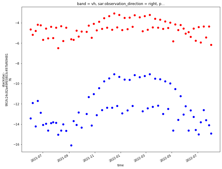
Note
good idea to link to SAR handbook for interpreting polarizations below or no?
Interesting! It looks like there is more variability in the VH band than the VV band. Chapter 2 of the SAR handbook contains information about how polarization impacts radar returns. The above plots are looking only at the ascending passes. Let’s take a look at all of the time steps (ascending + descending). Any effects based on the different viewing geometries of the ascending and descending passes should have been removed during the radiometric terrain correction step.
fig, ax = plt.subplots(figsize=(12,9))

power_to_db(da.sel(band='vv').mean(dim=['x','y'])).plot(ax=ax, linestyle='None', marker='o', color='red');
power_to_db(da.sel(band='vh').mean(dim=['x','y'])).plot(ax=ax, linestyle='None', marker='o', color='blue');
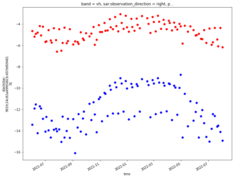
Next, let’s take a look at how backscatter values vary seasonally. To do this we will use xarray’s groupby() and .facetgrid methods.
seasons_gb = da.groupby(da.time.dt.season).mean()
#add the attrs back to the season groupby object
seasons_gb.attrs = da.attrs
---------------------------------------------------------------------------
NameError                                 Traceback (most recent call last)
Input In [2], in <cell line: 1>()
----> 1 seasons_gb = da.groupby(da.time.dt.season).mean()
      2 #add the attrs back to the season groupby object
      3 seasons_gb.attrs = da.attrs

NameError: name 'da' is not defined
seasons_gb
<xarray.DataArray 'stackstac-991fc24c82a49f65803c497bf6948176' (season: 4,
                                                                band: 2,
                                                                y: 1188, x: 869)>
dask.array<transpose, shape=(4, 2, 1188, 869), dtype=float64, chunksize=(1, 1, 1024, 869), chunktype=numpy.ndarray>
Coordinates: (12/28)
    sar:observation_direction              <U5 'right'
    platform                               <U11 'SENTINEL-1A'
    proj:epsg                              int64 32645
    sar:center_frequency                   float64 5.405
    sar:looks_range                        int64 5
    sar:resolution_azimuth                 int64 22
    ...                                     ...
  * band                                   (band) <U2 'vh' 'vv'
  * x                                      (x) float64 6.194e+05 ... 6.281e+05
  * y                                      (y) float64 3.102e+06 ... 3.09e+06
    title                                  (band) <U41 'VH: vertical transmit...
    description                            (band) <U173 'Terrain-corrected ga...
  * season                                 (season) object 'DJF' 'JJA' ... 'SON'
Attributes:
    spec:        RasterSpec(epsg=32645, bounds=(619420.0, 3089780.0, 628110.0...
    crs:         epsg:32645
    transform:   | 10.00, 0.00, 619420.00|\n| 0.00,-10.00, 3101660.00|\n| 0.0...
resolution: 10.0fg_vv = power_to_db(seasons_gb.sel(band='vv')).plot(col='season', cmap=plt.cm.Greys_r);
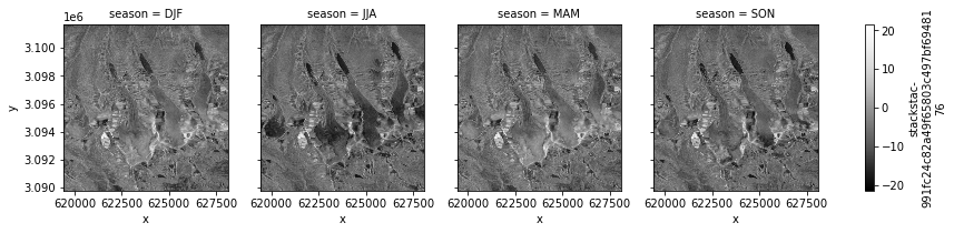
fg_vh = power_to_db(seasons_gb.sel(band='vh')).plot(col='season', cmap=plt.cm.Greys_r);
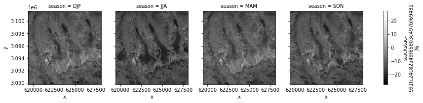
Wrap up#
This notebook demonstrated how to access cloud-hosted data from Microsoft Planetary Computer, some basic dataset organization and preliminary exploration and visualization. The following notebook will compare the Planetary Computer dataset to the ASF dataset.